Site and Setting
The 40-hectare (100-acre) ruin mound of Zincirli Höyük (latitude 37° 6′ North, longitude 36° 40′ East) contains the remains of the ancient walled city of Sam’al, nestled in a fertile valley just east of the Amanus Mountains. It was the capital of an Iron Age kingdom that flourished from around 900 to 700 BCE. The city had monumental palaces, massive outer walls, and ornate city gates adorned with sculpted stone reliefs. Buried below the Iron Age levels on the highest part of the upper mound is an earlier walled citadel of the Middle Bronze Age (2000–1600 BCE), which also had monumental architecture. Underneath the Middle Bronze Age remains of the upper mound and the Iron Age remains in the southern part of the lower town lies a still-earlier city of the Early Bronze Age (3000–2000 BCE).
The well-fortified city of Sam’al guarded a major pass over the Amanus Mountains. This high mountain range divides the North Syrian hinterland to the east from the Cilician plain and Mediterranean Sea to the west. The rulers of Sam’al controlled the caravan traffic from Mesopotamia that traveled westward to the Mediterranean from the Upper Euphrates River, leaving the river at a point about 100 kilometers east of Zincirli, where the Euphrates comes closest to the sea. The heavily forested Amanus Mountains were famous in antiquity for their timber, especially tall pine and cedar, which was shipped overland to the Euphrates and then downstream to treeless southern Mesopotamia in modern-day Iraq. Because of this favorable location, Zincirli attracted settlement by different groups over the centuries.
Zincirli is situated in a fertile valley about 60 kilometers south of the towering Taurus Mountains. The snow-capped Taurus range extends in an east-west direction across southern Turkey, reaching elevations as high as 3,700 meters. It separates the Anatolian plateau to the north from the Syro-Mesopotamian region to the south and east. In ancient times, the Taurus Mountains were a major barrier to travel and communication. There were only a few routes by which they could be crossed: principally, the mountain pass known as the “Cilician Gates,” through which runs the modern highway from Ankara to Adana, located 160 kilometers west of Zincirli on the far side of the Cilician plain; or, alternatively, by means of the valley of the Upper Euphrates River, 100 kilometers east of Zincirli, which connects the northbound traveler with a series of mountain valleys in eastern Anatolia through which ancient caravans passed.
The Names of the Site
Zincirli (pronounced “Zin-jeer-lee” and sometimes written “Zinjirli” or “Zenjirli” in the scholarly literature) is the modern Turkish name for the ruin mound (höyük, in Turkish) in which are buried the remains of the ancient city of Sam’al. The name Zincirli means “place of the chain” (Turkish zincir is “chain”). It supposedly got this name in the Ottoman period because a military well along the road that passed by the site possessed an iron chain—an unusual feature in this rural region, which was populated at that time mainly by nomadic herders.
Śam’āl (written ŚM’L in ancient alphabetic inscriptions and Sá-am-a-al or Sá-ma-al-la in cuneiform inscriptions) was a name used for Zincirli and/or the surrounding region in the Bronze and Iron Ages. It is a Northwest Semitic word that means “north,” and its use as a geographical name probably reflects the perspective of Semitic-speakers from the south. Judging by an Old Assyrian text in which it is mentioned, this name was in use already in the Middle Bronze Age, in the nineteenth century BCE, when an Amorite elite dominated most of the Levant. And it may have been used even earlier, in the Early Bronze Age, during the time of the powerful kingdom of Ebla, when the site of Zincirli was first occupied by a large town.
The remote valley in which Zincirli lies, bordered on the west and north by high mountains but open to the south and east, is indeed the northernmost region in which Semitic-speaking populations lived in ancient times. Northwest Semitic śam’āl (Hebrew śǝm’ōl, with the Canaanite vowel shift of ā to ō) literally means “left,” but it also means “north,” because that is the direction to your left as you face east, toward the rising sun (compare Arabic šamāl, which also means “north”). Following scholarly convention, we will dispense with the diacritical mark that distinguishes śīn from samekh in Latin transliteration and the macron that indicates vowel length, but we will indicate the aleph, and thus render the name as “Sam’al” instead of “Śam’āl” or “Samal.”
Another ancient name for Zincirli and/or the surrounding region that appears in Iron Age alphabetic inscriptions, written without consonants, is Y’DY. We do not know how to pronounce it: one suggestion is “Yādiya.” This name does not appear to be Semitic, indicating that there was a non-Semitic-speaking population living in the area as well. This was the result, most likely, of a migration into the Zincirli region during the Late Bronze Age under the aegis of one of the foreign empires that dominated the Northern Levant in the last half of the second millennium BCE—a migration either of Hurrian-speakers within the Mittannian Empire (ca. 1480–1340 BCE) or of Luwian-speakers from Anatolia during the period of the Hittite Empire (ca. 1340–1200 BCE).
Physical Environment
Zincirli lies immediately adjacent to the eastern foothills of the Amanus Mountains (called Nur Dağları in Turkish; literally, “Mountains of Holy Light”). This is a steep mountain range that extends southward from the Taurus Mountains and separates the broad and lush plain of Cilicia to the west from the Syrian interior and the Euphrates River to the east. About 100 kilometers south of Zincirli is the prominent classical city of Antioch on the Orontes River (modern Antakya), which is located 20 kilometers west of the Bronze and Iron Age site of Tell Ta‘yinat (shown in the map above). Antioch in the classical period and Tell Ta‘yinat in earlier periods were strategically positioned near the eastern outlet of the main southern pass over the Amanus Mountains: the Belen Pass, known in classical times as the “Syrian Gates.” Likewise, Zincirli is positioned at the eastern outlet of the northern pass across the Amanus range, astride the ancient caravan route that ran from the Cilician plain (ancient Quwê, famous for its horses) up through the forests and logging camps of the Amanus toward the Euphrates River, and from there to the great population centers of Mesopotamia.
The long, narrow valley in which Zincirli is situated is only 10–20 kilometers in width. The eastern side of this valley is bordered by the Kurt Dağ, a range of low mountains. The Karasu River, a northern tributary of the Orontes, flows southward through the valley, which lies along a major geological fault. In fact, the narrow valley in which Zincirli lies is the northernmost extension of the 6,000-kilometer Syro-African Rift that skirts the eastern shore of the Mediterranean and includes the valley of the Orontes River in western Syria, the Bekaa Valley in Lebanon, and, further south, the Sea of Galilee, Jordan River, and Dead Sea, and ultimately extends all the way to Mozambique in East Africa.
Climate and Natural Resources
Zincirli is in a Mediterranean-type climatic zone characterized by hot, dry summers and cool, rainy winters, with abundant resources for rain-fed agriculture in the valley bottom and for pasturing herds and flocks in the nearby hills. The Amanus Mountains receive substantial precipitation, averaging 1,000 millimeters or more per year. In ancient times, before modern deforestation due to logging and overgrazing, the mountain slopes supported dense forests consisting mainly of coniferous species such as fir, spruce, cedar, pine, and juniper. This region was thus a major source of high-quality timber and other tree products such as resin, which were exported to the great cities of Syria and Mesopotamia from very early times.
East of Zincirli, where annual rainfall rapidly declines with increasing distance from the sea due to the rain shadow cast by the Amanus Mountains, the dense forest of ancient times gave way to a typical Mediterranean scrubland or maquis, consisting of clumps of terebinth, oak, pistachio, and other small trees and broad-leaved evergreen shrubs—many of them aromatic, such as mint, laurel, and myrtle.
Wild game abounded around Zincirli in ancient times, as is attested by the hunting scenes found on Iron Age stone reliefs at Zincirli and by animal bones excavated at the site. Native to the wooded mountains and foothills near the site were deer, hares, and wild boars, as well as large predators such as wolves, lions, and bears. The streams and marshes of the Karasu River valley were home to a wide variety of fish, turtles, and water fowl, augmented by the millions of migratory birds that passed through the narrow valley in their seasonal movements from Russia to Africa.
In addition to these wild resources, the ancient inhabitants of Zincirli farmed the rich soils of the valley, raising wheat and barley, as well as various vegetables, and cultivating grapes, olives, and figs—for all of which there is excavated botanical evidence as well as ancient textual documentation. These crops, combined with the herding of sheep, goats, and cattle, and the hunting of wild game, provided a typical Mediterranean subsistence economy in ancient Sam’al.
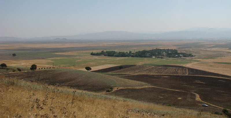
A view of Zincirli, facing east, as seen from the foothills of the Amanus Mountains. The western half of the site is covered in the trees and houses of a modern village. The low mountain range called the Kurt Dağ is visible in the distance, bordering the eastern side of the fertile valley in which Zincirli is situated.
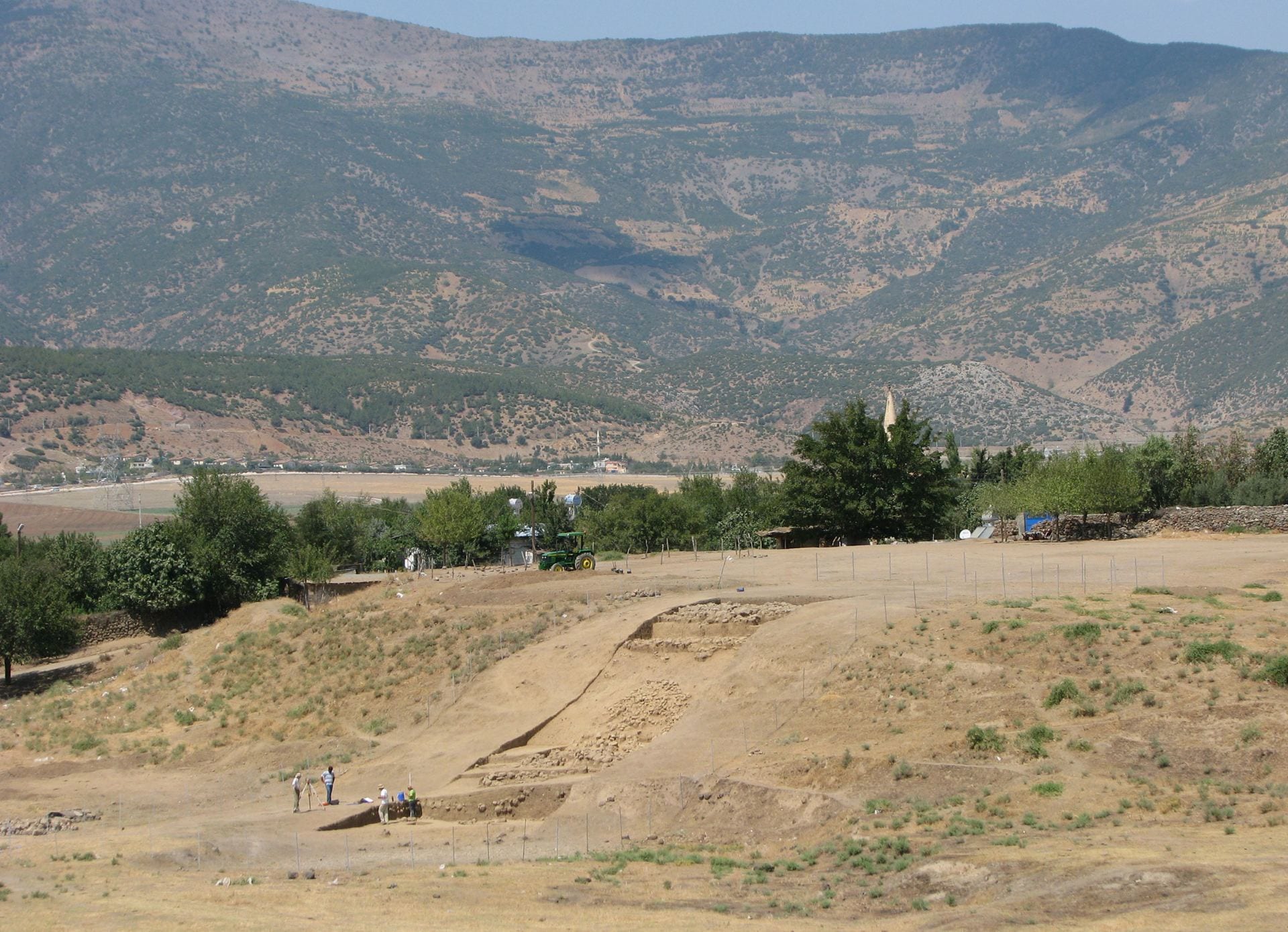
A view, facing northwest, of the upper mound of Zincirli, with the Amanus Mountains looming in the background. The mountain slopes were more thickly forested in the Bronze and Iron Ages, and teemed with wild game, such as are depicted on the Iron Age reliefs found at the site. But intensive logging and grazing in recent centuries have caused soil erosion, and a more meager second-growth forest now blankets the slopes. In the foreground is the 2007 excavation trench in Area 3 (the Southern Citadel), in which remnants are visible of the stone glacis that covered the earthen rampart of the Iron Age royal citadel. The trees and houses of the modern village occupy the western side of the site.