Settlement History
A major goal of the current excavations has been to understand the settlement history of the site of Zincirli. We have worked in ten widely separated areas of the 40-hectare site in order to obtain a representative sample of the various periods of occupation. By combining our results with the results obtained from the previous excavations, which focused mainly on the upper mound, we have been able to develop a clearer picture of the history and character of the settlements at the site in various periods from ca. 3000 to 300 BCE. Of particular interest are the extensive remains of the Middle Bronze Age and of the Early Bronze Age, which have begun to emerge in recent years. In both of those periods, there were significant occupations that ended in violent destruction, indicating the political significance of the site long before the Iron Age—the period for which the site is best known.
Early Bronze Age
The site of Zincirli has a long history of settlement, from the Early Bronze Age (ca. 3000–2000 BCE) to the modern era, although the site was not continuously occupied. The German expedition collected a great deal of pottery from the upper mound beneath the Iron Age royal citadel, some of which is now stored in the Vorderasiatisches Museum in Berlin. Comparison of this pottery with similar ceramics from sites excavated later, such as Tarsus to the west in Cilicia; Tell Ta‘yinat and other sites in the Plain of Antioch (the Amuq) to the south; and the nearby sites of Tilmen Höyük and Gedikli Höyük, shows that this pottery dates to the Early Bronze Age. This distinctive brick-red pottery, which sometimes has incised geometric decoration, has been nicknamed “Brittle Orange Ware.”
Our excavations have reached Early Bronze Age occupational remains in two small areas on the upper mound, in Area 2 (Eastern Citadel) and Area 3 (Southern Citadel). In Area 3, the Early Bronze Age level seems to have terminated in a fiery destruction. Excavations in 2015 beneath the southern part of the Iron Age lower town in Area 4 and Area 8 revealed for the first time that the Early Bronze Age settlement extended southward from the upper mound, forming a lower town underneath the southern portion of the Iron Age lower town. In the north, the Iron Age lower town was founded on previously unoccupied land, so the Early Bronze Age city was apparently confined to the southern half of the Iron Age settlement. Preliminary indications from Area 4 suggest that the Early Bronze Age lower town had at least two phases, and that the earlier phase was destroyed by fire. Preliminary radiocarbon dates indicate that this destruction took place in the Early Bronze Age IV in the second half of the third millennium BCE, during the time of the powerful Ebla kingdom based in northern Syria or shortly after its fall.
In 2007, we explored a chamber tomb that had been cut into a limestone outcrop on a hilly slope several hundred meters west of Zincirli. This tomb contained vessels dating to the Early Bronze Age and the remains of multiple individuals. Unfortunately, it had been badly disturbed by recent looters.

Expedition staff members Leann Pace, Christoph Bachhuber, and Başak Boz excavating the rock-cut chamber tomb dating to the Early Bronze Age that was discovered in a limestone outcrop on a hill west of Zincirli
Middle Bronze Age
Zincirli was occupied during the Middle Bronze Age (ca. 2000–1600 BCE). This is the Old Babylonian period in central and southern Mesopotamia, contemporary with the powerful Amorite kingdom of Yamhad, based in Aleppo, which dominated much of the Northern Levant. It is also the period when a far-flung network of Old Assyrian donkey-caravan routes stretched from the city of Aššur on the Tigris River in northern Iraq all the way to central Turkey. An Old Assyrian cuneiform tablet found at Kanesh (modern Kültepe) mentions a person from Sam’al (sá-am-a-al) who was employed by a trading expedition to procure timber from the mountains—presumably the Amanus Mountains. This suggests that Zincirli, which was located at the start of a major route up into the mountains, was already called Sam’al in the Middle Bronze Age.
Scattered finds and ceramic fragments from the German excavations had long ago suggested the presence of a Middle Bronze Age occupation at Zincirli. This was confirmed only in 2015, however, by the discovery of intact structures beneath the Iron Age levels in Area 2 on the Eastern Citadel. The Middle Bronze Age II stratum was destroyed in a fiery conflagration in the seventeenth century BCE, leaving much of the contents of the rooms in place, sealed or smashed beneath the collapse of the ceilings and walls. Our excavations of this stratum in Area 2 have so far uncovered parts of two buildings separated by a narrow street and containing many restorable pottery vessels and special finds such as figurines, cylinder seals, and seal-impressed clay bullae. A Middle Bronze Age destruction layer has also been encountered, but not yet explored, in Area 3 on the Southern Citadel, east of the main trench.
Excavations in 2017 to broaden the exposure of this destruction layer revealed that the massive rectangular stone foundations known as Hilani I, long considered to be the oldest palace of the Iron Age kings of Sam’al, were actually constructed during the Middle Bronze Age. The presence of such a monumental structure at Zincirli is causing us to rethink the function of the site in the Middle Bronze Age and its relationship to Tilmen Höyük, a 5-hectare site located 8 kilometers south of Zincirli that was also occupied in the Middle Bronze Age and has been extensively excavated by Turkish and Italian archaeologists. In this period and the following Late Bronze Age I, Tilmen Höyük had a monumental palace, temples, and massive fortifications. If Tilmen’s identification as ancient Zalwar/Zalbar is correct, it was destroyed by the first great Hittite king, Hattušili I, in the mid-seventeenth century BCE, as recorded in his Annals, and the fortified site of Zincirli was presumably destroyed in the same campaign.
Late Bronze Age and Iron Age I
In our excavations on the upper mound in Area 2 and Area 3, we observed that the Iron Age occupation was founded directly on top of the destroyed remains of the Middle Bronze Age city. This indicates a gap in occupation at Zincirli, which is confirmed by the fact that only a small handful of pottery fragments dating to the Late Bronze Age (ca. 1600–1200 BCE) and the Iron Age I (ca. 1200–900 BCE) have been found, despite the large scale of excavation on the upper mound. It seems that Zincirli was abandoned for several centuries after its destruction in the Middle Bronze Age II, although Tilmen Höyük and Taşlı Geçit Höyük, located farther south in the Karasu Valley, were rebuilt during the Late Bronze Age I.
In the Late Bronze Age I, the region around Zincirli came under the hegemony of the Mitannian Empire based in northern Mesopotamia. Subsequently, in the Late Bronze Age II, this region and all of the Northern Levant were incorporated into the Hittite Empire, which was based in central Anatolia. The city of Carchemish, 100 kilometers east of Zincirli on the Euphrates River, became the regional center of Hittite rule and the seat of a Hittite viceroy. Zincirli and Tilmen were both unoccupied in the Hittite period, although in order to police this important corridor of travel and trade, the Hittites must have had a local center somewhere in the Karasu Valley, perhaps at the hilltop site of Gercin, 7 kilometers north of Zincirli, where the Iron Age kings of Sam’al patronized the temple of the storm-god Hadad and established a mortuary cult. However, further archaeological surveys and excavations are necessary to determine the location of the Hittite and post-Hittite center of the Late Bronze Age II and Iron Age I.
After the collapse of the Hittite Empire around 1200 BCE, Carchemish continued to be controlled by members of the Hittite royal dynasty and still exercised considerable influence, if not outright hegemony, in the Zincirli region. Twenty-three kilometers southeast of Zincirli, at the stone quarry of Yesemek, hundreds of large sculptures of lions, sphinxes, and mountain gods were abandoned on the surface in the process of production. They can be dated stylistically to the period just before or after the collapse of the Hittite Empire and were likely intended for a major monumental building that was never completed. Finished and unfinished sculptures in this style have been found in Iron Age II levels at Zincirli, but they must have been brought there centuries later for reuse in the royal citadel because Zincirli was not occupied during the period of their production. Other relief-carved orthostats that may be dated stylistically to the Iron Age I, as well as a fragmentary inscription in the Hieroglyphic Luwian script and language, suggest that a local Luwian-speaking (Neo-Hittite) regime dominated the Karasu Valley in the eleventh and tenth centuries BCE (Herrmann et al. 2016; Herrmann 2017). It is possible that the geographical name Yādiya (Y’DY), which is used as an alternative name for Sam’al in some later inscriptions, and which seems to be Luwian rather than Semitic, originated in this period. Luwian, an Indo-European language spoken widely in Hittite Anatolia and written in a distinctive hieroglyphic script, was the language of the Anatolian people stationed in North Syria as soldiers and administrators under the Hittite Empire, or who migrated there after the collapse of the empire to escape the turmoil in Anatolia.
Iron Age II and III
The re-occupation of the mound of Zincirli in the late tenth or early ninth century BCE, after centuries of abandonment in the Late Bronze Age and Iron Age I, is attributed by many scholars to Arameans who had migrated from their putative homeland in the Euphrates River region, hundreds of kilometers to the southeast. Personal names in inscriptions of the period suggest that warlords who spoke one dialect or another of Aramaic managed to establish small kingdoms west of the Euphrates River during the Iron Age II, often at the expense of the Luwian-speaking “Neo-Hittite” rulers of Anatolian extraction who had dominated the area in the Iron Age I.
A ruler named Gabbār, mentioned in later inscriptions as the founder of the royal dynasty of Sam’al, may have been one of these migratory warlords. However, it is possible that Gabbār and his warriors were not invading Arameans, as is commonly assumed, but were in fact indigenous Northwest Semitic-speakers descended from the Middle Bronze Age inhabitants of the remote intermontane valley in which Zincirli lies. There is no archaeological or artifactual evidence for an Aramean incursion. In fact, the only evidence is linguistic, based on the language of the Iron Age royal inscriptions of Sam’al and the names of Sam’alian kings such as Barṣūr and Barrākib. These names contain the typically Aramaic word bar, meaning “son,” as opposed to bin, which is found in other Semitic languages. But the use of bar instead of bin could easily be a coincidence resulting from independent linguistic development. Lexical similarities are a weak basis for determining linguistic affiliation. It is more telling, from the point of view of linguistic classification, that the Sam’alian dialect of the Iron Age does not share morphological innovations found in all other examples of Aramaic, calling into question its classification as Aramaic (Huehnergard 1995; Noorlander 2012; Pat-El and Wilson Wright, forthcoming). Sam’alian might well have belonged to an otherwise-unattested branch of Northwest Semitic indigenous to the Zincirli region. Furthermore, there is evidence that the place name Sam’al (a Semitic word meaning “north”) was in use long before the Iron Age. It was probably the old Amorite name of the site, or perhaps even a pre-Amorite name from the period of the Ebla kingdom in the third millennium BCE, because the place-name Sam’al appears in an Old Assyrian text of the nineteenth century BCE that was found at Kültepe, ancient Kanesh, in central Anatolia (Nashef 1987: 18–20, text no. 7).
In any case, our excavations have made it clear that Gabbār’s royal citadel at Zincirli was initially restricted to 4 or 5 hectares on top of the abandoned Bronze Age mound, and only later did he—or, more likely, one of his successors—greatly expand and massively fortify the site with the addition of a large lower town that now forms the lower mound. It is increasingly apparent that the royal citadel on the upper mound was enlarged and re-fortified no earlier than the late ninth century BCE, and perhaps as late as the eighth century. An imposing outer fortification consisting of two concentric circular walls was constructed at that time on open land, 360 meters from the center of the royal citadel. The result was a much larger walled area of 40 hectares, at the center of which was an enlarged 8-hectare royal citadel.
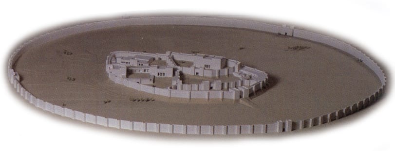
A model of the city walls, gates, and palaces of Iron Age Sam’al, based on the results of the German expedition
The Iron Age Fortifications and Their Decoration
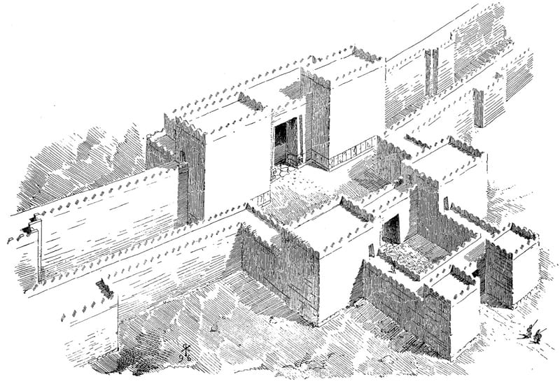
The outermost wall of the Iron Age lower town was 3 meters wide. Its foundations were more than 3 meters in height and were built of large rough-hewn basalt boulders. On top of the stone foundation was a massive mudbrick superstructure, now completely eroded away, that would have risen to a height of at least 10 meters. The outermost wall ran for a distance of 2,200 meters in a perfect circle around the site. It had 100 rectangular towers, evenly spaced about 15 meters apart, which projected outward from the wall and served as firing platforms for archers and spearmen defending the city. A concentric wall, also 3 meters wide but with a shallower foundation made of smaller stones, was built 7 meters inside the outer wall, forming a double-walled fortification system—a formidable obstacle to any attacker, who, having captured the outermost wall, would have been trapped in the gap between the walls and subjected to withering fire from defenders on the inner wall. The inner wall also had projecting towers that were aligned with the outer wall’s towers. The previous excavators had traced the entire circuit of these walls and towers, and explored the three monumental gates set into the double-wall fortifications. In the current excavations, we have re-investigated the outer fortifications by digging in Area 1 beside the Northeast Gate. We have also investigated the northern edge of the South Gate and the southern edge of the lower town just inside this gate in our Area 4.
The Northeast Gate and the West Gate did not contain any sculptures, but the much larger South Gate, which occupied 1,800 square meters, including a central courtyard of over 400 square meters, was the main entrance into the city and was decorated with sculpted orthostats. In all three gates, basalt orthostat slabs were placed along the lower margins of the mudbrick walls that lined the gateway. The orthostats in the South Gate were carved in relief to depict a series of human, animal, and supernatural figures, echoing the earlier Hittite and Neo-Hittite way of decorating gates. The eight preserved orthostats uncovered in the first excavations at Zincirli in 1888, in the Citadel Gate on the south side of the royal citadel, show winged bird-headed guardian figures; an archer hunting a stag; two fantastic animals (a griffin and a sphinx); a horseman holding the severed head of an enemy; and two standing male figures facing each other with cups raised to their mouths. These sculptures communicate a message of supernatural protection, the taming of humans and animals, and dynastic stability appropriate to the founding of a new city. They were carved in the earliest artistic style found in Iron Age Zincirli. In fact, it is possible that these were earlier Neo-Hittite sculptures dating to the Iron Age I that had been taken from another site and reused in the new city of Sam’al (Herrmann 2017).
Robert Koldewey’s reconstruction of the South Gate of Sam’al
During the Iron Age II, the old Bronze Age mound in the center of the site was made into a heavily fortified citadel by the construction of a new wall with a single gate on its south side—the Citadel Gate, mentioned above—and with semicircular towers placed in this wall at regular intervals. The citadel wall was exposed in several places by the previous excavations; however, new details concerning its construction have been revealed by our main excavation trench in Area 3, which runs over and down the southern slope of the upper mound about 30 meters west of the Citadel Gate.
This gate was the only means of access into the royal precinct on the upper mound and it was even more elaborately decorated than the South Gate of the outer wall. The Citadel Gate had forty stone orthostats, all carved in a similar style. A pair of stone lions and a pair of stone bulls flanked and protected the two doors of the gate. The orthostats on the east side of the gate depicted processions of gods accompanied by musicians, while those on the west side showed worldly scenes of hunting, rulers, warfare, and the royal ancestor cult. The rulers and the gods with their horned hats and weapons are all anonymous, unidentified by any inscription, but the goddess with a tall hat holding a mirror may be Kubaba, “queen” of Carchemish, an important Hittite and Neo-Hittite city located 100 kilometers east of Zincirli on the Euphrates River.

An interior wall within the royal citadel controlled access from the lower terrace in the southeastern area of the upper mound by the Citadel Gate into the higher palace area in the north. The inner gate leading through this interior wall into the palace area was once guarded by huge stone lions whose bodies were carved in relief and heads in the round. Five of these lions, of varying styles dating to different periods, were found in a large pit in front of the inner gate, having been ceremonially buried when the inner gate went out of use.
The Hilani Palaces
The classic Iron Age North Syrian palace form, known as the bīt-hilāni in Akkadian cuneiform texts that describe imitations of this form in Neo-Assyrian palaces, was first identified at Zincirli. Other examples have since been found at Tell Ta‘yinat, Carchemish, Tell Halaf, and other sites of the period. However, Zincirli still boasts the largest number of examples of this architectural form. Six hilani palaces built at different times were excavated in the royal citadel by the German expedition. Each of them had a monumental façade, sometimes approached by steps, with a portico supported by two wooden pillars that rested on massive decorated stone bases. Behind a broad entrance room lay the main reception hall of the palace. The entrance room led into several smaller rooms in the back of the building and gave access to a staircase leading up to the upper story.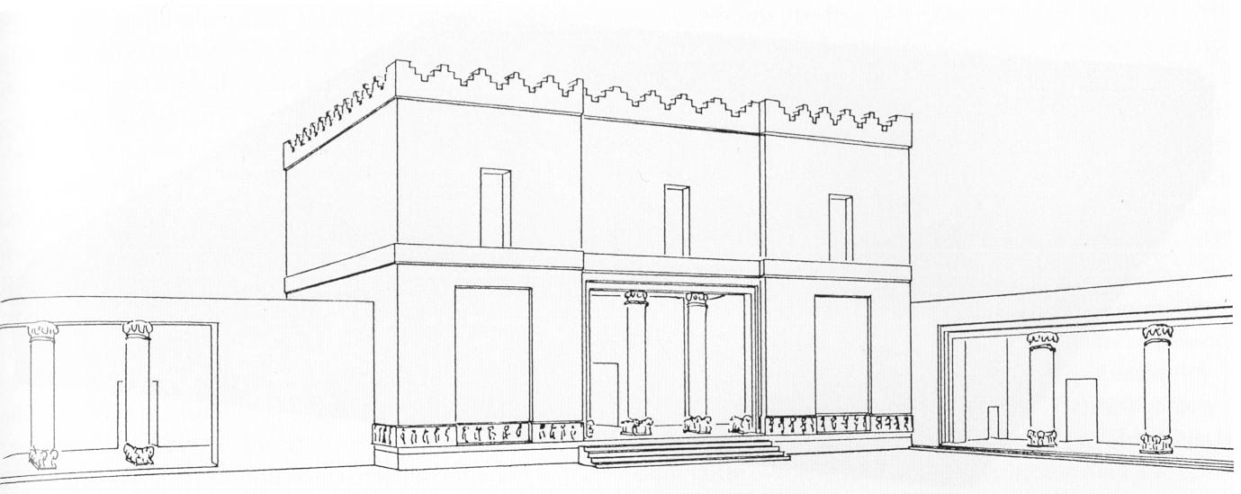
Artist’s reconstruction of Hilani III in the nortwestern palace area of the royal citadel of Sam’al
The oldest hilani building at Zincirli, Hilani I, is situated on the highest part of the mound in Area 2 of the current excavations (the Eastern Citadel). Until recently, this building, of which only the massive stone foundations are preserved, was long thought to date to the reign of Gabbār himself, the founder of the dynasty. However, our excavations in Area 2 have shown that Hilani I was originally constructed a thousand years earlier, in the Middle Bronze Age. This confirms other indications that the Iron Age hilani architectural form originated already in the Bronze Age Northern Levant, but it raises the question of where the first kings of Iron Age Sam’al resided. In the northwestern part of the upper mound, the German expedition unearthed two hilani palaces (Buildings J and K) situated side-by-side facing onto a large courtyard. The entrance to Building J was flanked by an orthostat on which was carved a portrait of its builder, Kulamuwa, the king of Sam’al in the period after the conquest of the region by Shalmaneser III of Assyria in the 850s BCE. This orthostat is dated to ca. 830 BCE and bears an inscription in the Phoenician language and written in a variant of the Phoenician alphabetic script. Kulamuwa is depicted on the orthostat in the style of a Neo-Assyrian king and his inscription describes how he “hired” the king of Assyria to fight against his rivals the Danunians, who lived on the other side of the Amanus Mountains in Cilicia to the west. Kulamuwa boasts that he brought prosperity to his kingdom (called Y’DY in this inscription) and made peace between two rival groups: the muškabīm and the ba‘rīrīm. It is possible that Kulamuwa misrepresents the relationship between his small kingdom and mighty Assyria, to which he likely paid tribute, for his father Ḥayya had lost a bloody battle against the Assyrian king Shalmaneser III in 858 BCE and had sworn loyalty to Assyria, pledging annual tribute of silver, cedar beams, and resin and giving his daughter to Shalmaneser with a rich dowry. Before Kulamuwa ascended to the throne, the rulers of Sam’al, like those of the other small kingdoms west of the Euphrates, had become vassals of the expanding Neo-Assyrian Empire.
None of the buildings excavated at Zincirli dates to the early or mid-eighth century BCE, but it was then that the great statue of the god Hadad bearing a memorial inscription of King Panamuwa I (ca. 790–750 BCE) was set up at the nearby hilltop site of Gercin, 7 kilometers to the northeast. The Hadad inscription of Panamuwa I is written in the local Sam’alian dialect and cautions against violence within the royal house. But this warning was not heeded, and Panamuwa’s reign was followed by a period of internal strife in which an unknown usurper killed the new king, Barṣūr, and many of his relatives, causing Barṣūr’s son Panamuwa (II) to flee into exile. The exiled prince sought the aid of the Assyrian king Tiglath-pileser III, who was then in the process of expanding the Neo-Assyrian Empire and bent on conquering the entire Levant. Tiglath-pileser III installed Panamuwa II on the throne of Sam’al in the course of putting down a western coalition backed by Assyria’s rival Urartu in 743–740 BCE. Panamuwa II now became a favorite of Tiglath-pileser III, loyally assisting him in his campaigns and deportations, and paying annual tribute. He was rewarded by grants of land taken from disloyal neighbors. His memorial inscription, written in Sam’alian on a colossal statue of Panamuwa II erected by his son and successor Barrākib, tells how Panamuwa II was killed fighting alongside the Assyrians at Damascus (733/732 BCE) and was mourned and honored by Tiglath-pileser III and all his vassals.
Barrākib, the son of Panamuwa II, was confirmed on the throne of Sam’al by Tiglath-pileser III, and his inscriptions are effusive in their declarations of loyalty to Assyria. He called himself “the servant of Tiglath-pileser, lord of the four quarters of the earth” and proclaimed that he “ran at the wheel of my lord, the king of Assyria.” Unquestioning loyalty seems to have profited both Barrākib and his father, for they sponsored extensive new building projects. The northwestern palace area on the upper mound of Zincirli was greatly enlarged and elaborated by the construction of Hilani III, which was decorated with carved orthostats depicting a procession of courtiers and featured two massive stone column bases, each carved in the form of a double-sphinx; and also by the construction of another smaller hilani palace (the “Nordöstlicher Hallenbau,” or Hilani IV), which was decorated with orthostats showing a procession of musicians and servants, and also a scribe standing before the enthroned king Barrākib. Carved ivories, jewelry, and silver ingots inscribed with the name of Barrākib and found in Building J attest to the wealth of the king in this period.
The Lower Town
Other than tracing the outer fortification walls and gates, the German expedition hardly touched the lower town that makes up most of the site. In contrast, it has been a major priority of the current excavations to investigate the lower town in order to learn about the economic organization and social life of the city. In 2007, a geomagnetic survey of all accessible parts of the lower town (ca. 20 hectares) revealed the plan of seventh-century BCE structures of the Neo-Assyrian provincial period in remarkable detail (Casana and Herrmann 2010). The lower town was densely occupied in this period (the blank area in the geomagnetic map in the eastern part of the lower town is due, unfortunately, to the removal of the ancient remains by modern activity). The streets inside the lower town are clearly visible as lighter strips between the darker buildings. Radial roads ran from the outer gates toward the citadel, while two concentric ring roads followed the curve of the outer walls and gave easy access to all parts of the city. Closer to the citadel, this radial and concentric road system was either replaced by a less coherent network or it has been obscured by later activity.
The geomagnetic survey also discovered two single-period buildings of the late eighth and/or seventh century BCE that lay outside the city walls. Both of these buildings have since been excavated. A large building with paved courtyards was exposed in Area 0, 150 meters north of the Northeast Gate. It may have been a trading station or customs house. A small, square broadroom temple was exposed in Area 7, 60 meters south of the South Gate. A large sculpted orthostat depicting an unnamed ruler was found just west of this temple in 2008.
The architectural plan is most clearly visible in the geomagnetic map of the Northern Lower Town, where we opened two large excavation areas: Areas 5 and 6. The geomagnetic survey revealed a cluster of several large elite residences in this part of the site, each of which had rooms arranged around a pair of central courtyards. This double-courtyard arrangement is the typical plan of palaces and elite residences in Neo-Assyrian capital cities and provincial centers found elsewhere in the Neo-Assyrian Empire. We excavated portions of two large courtyard complexes in Areas 5 and 6, showing that after the Assyrian takeover, during the reigns of the last kings of Sam’al and then under direct imperial rule by a provincial governor, the highest nobles and officials lived in the northern part of the lower town under the eye of the palaces on the citadel above.
Surrounding these elite residences were complexes of much smaller buildings of more irregular plan. Nine small buildings belonging to one of these complexes on the edge of the elite zone have been excavated in Area 5. Circular bread ovens, baked brick hearths, basalt grinding stones, polished stone spindle whorls, and iron tools are the typical inventory of these buildings. The animal bones and pottery found in Area 5 also provide data concerning the diet and agropastoral economy of the inhabitants of Sam’al. In one of the small buildings in Area 5 we found the inscribed mortuary stele of a royal official named Katumuwa. The text, image, and archaeological context of this stele, found in situ in a mortuary chapel adjacent to a neighborhood temple, have given us important new information about the mortuary cult in the Iron Age Northern Levant.
Excavations in Areas 4, 8, and 9 in the southern part of the lower town are also providing new information about the urban fabric of Sam’al and the daily life of its inhabitants in the ninth through seventh centuries BCE.
Annexation by Assyria
Only a few years after the construction of Barrākib’s palaces—no later than 713 BCE, based on an Assyrian document of that year which mentions a local provincial governor in Sam’al—the kingdom was annexed as a directly-ruled province and its native royal dynasty was deposed. The seemingly strong relationship between vassal and overlord had somehow soured or become impossible. Unfortunately, we know nothing about the circumstances of this political change other than the fact that it was apparently peaceful, because no destruction dating to this period has been found. We know the name of one Assyrian governor of Sam’al from the early decades of the provincial period: Nabû-ahhē-ēreš, who is mentioned in a cuneiform document from 681 BCE. But there seems to have been no new building activity in this period. Instead, the governors of Sam’al used the old royal palaces, as is shown by the discovery of Assyrian cuneiform tablets dated to 713 and 671 BCE in Building J (Faist 2013–2014). These palaces were destroyed in a fierce fire around 670 BC, apparently in retaliation for a rebellion in Sam’al that can perhaps be connected to a conspiracy within the Neo-Assyrian Empire against Esarhaddon (Radner 2003–2004). After this destruction, the old royal palaces were never rebuilt and instead a new palace, Palace G, was constructed in a hybrid Assyrian/Neo-Hittite style over the foundations of Hilani I in the northeastern part of the upper mound. At the same time, the large Hilani II was built in the center of the upper mound and a huge stele depicting the Assyrian king Esarhaddon and inscribed in Akkadian cuneiform with an account of the king’s campaign against Egypt in 671 BCE, was erected in the Citadel Gate. It presumably symbolized the renewed loyalty of Sam’al to Assyria. But a few decades later the Assyrian buildings were themselves destroyed and the city was evacuated and abandoned, probably around the time when the Neo-Assyrian Empire fell to the Babylonians and Medes in 612–605 BCE, or perhaps a bit earlier.
In the current excavations we have discovered a small broadroom temple of the Assyrian provincial period in Area 3 in the Southern Citadel. The lower town continued to be occupied in this period, as shown by our excavations in Areas 5 and 6 in the Northern Lower Town, and by excavations in Area 4 near the South Gate, Area 8 in the Southwestern Lower Town, and Area 9 in the Southeastern Lower Town. It was in this period, also, that a large double-courtyard structure (Complex C) was constructed in Area 6 in the Northern Lower Town. This elite residence was as large as Palace G on the citadel (presumably the residence of the provincial governor), indicating that the lower town was home to high officials or noblemen of considerable importance in the Neo-Assyrian province of Sam’al.
Persian and Hellenistic Periods
The previous excavators of Zincirli in the nineteenth-century German expedition found some walls, pottery, and other small finds dating to the late Persian or early Hellenistic periods (fourth and third centuries BCE) but did not extensively document these remains. The current excavations have revealed part of a large administrative building and a fortification wall of this period in Area 3 in the southern part of the upper mound. These probably belonged to a fortress built under the aegis of the Achaemenid Persian Empire to control the nearby pass over the Amanus Mountains, which the army of Darius III used in 333 BCE to cross over to the Mediterranean coast and attack the army of Alexander the Great from the rear in the Battle of Issos (as described by later Hellenistic historians). The large lower town of the Iron Age remained completely abandoned, however.
A new Greek city called Nikopolis was founded during the Hellenistic period at modern İslahiye, 10 kilometers south of Zincirli. Early in the Hellenistic period, sometime around 300 BCE, the upper mound of Zincirli was abandoned once again, after which the site remained unoccupied for more than two millennia until a small village was built there in the nineteenth century CE.
Modern Village
When the German expedition began in 1888, there were already some houses ranged around the foot of the upper mound of Zincirli on its western and southern sides. Other houses were scattered across the northwestern part of the site where the Iron Age lower town had once been, and there were dozens of Ottoman-period burials in a cemetery along the eastern edge of the lower town.
In the years following the German excavations, which ended in 1902, the modern village of Zincirli grew to cover the northwestern quadrant of the Iron Age lower town and the western half of the royal citadel on the upper mound. A number of houses were built directly on top of excavated Iron Age palaces and other royal buildings, which had been left exposed in the wake of the extensive German excavations. The houses of the modern village were in many cases constructed using stones taken from those ancient buildings. Since 2006, many of the current inhabitants of Zincirli village have worked with the archaeologists in the new excavations and have provided valuable information concerning the history of the village, and oral lore about the German excavations in which their ancestors participated.