Current Excavations
The current excavations at Zincirli commenced in 2006 under the auspices of the Oriental Institute of the University of Chicago and, since 2014, in partnership with the Institut für die Kulturen des Alten Orients of the University of Tübingen. A multi-national team of 30–60 archaeologists, archaeology students , and specialists works at the site for two months each summer with the aid of several dozen workers hired from villages in the vicinity. The current excavations have added a great deal to what was previously known about the site, generating new insights into the culture, society, and economy of the kingdom of Sam’al—and, by extension, other similar kingdoms of the ancient Levant.
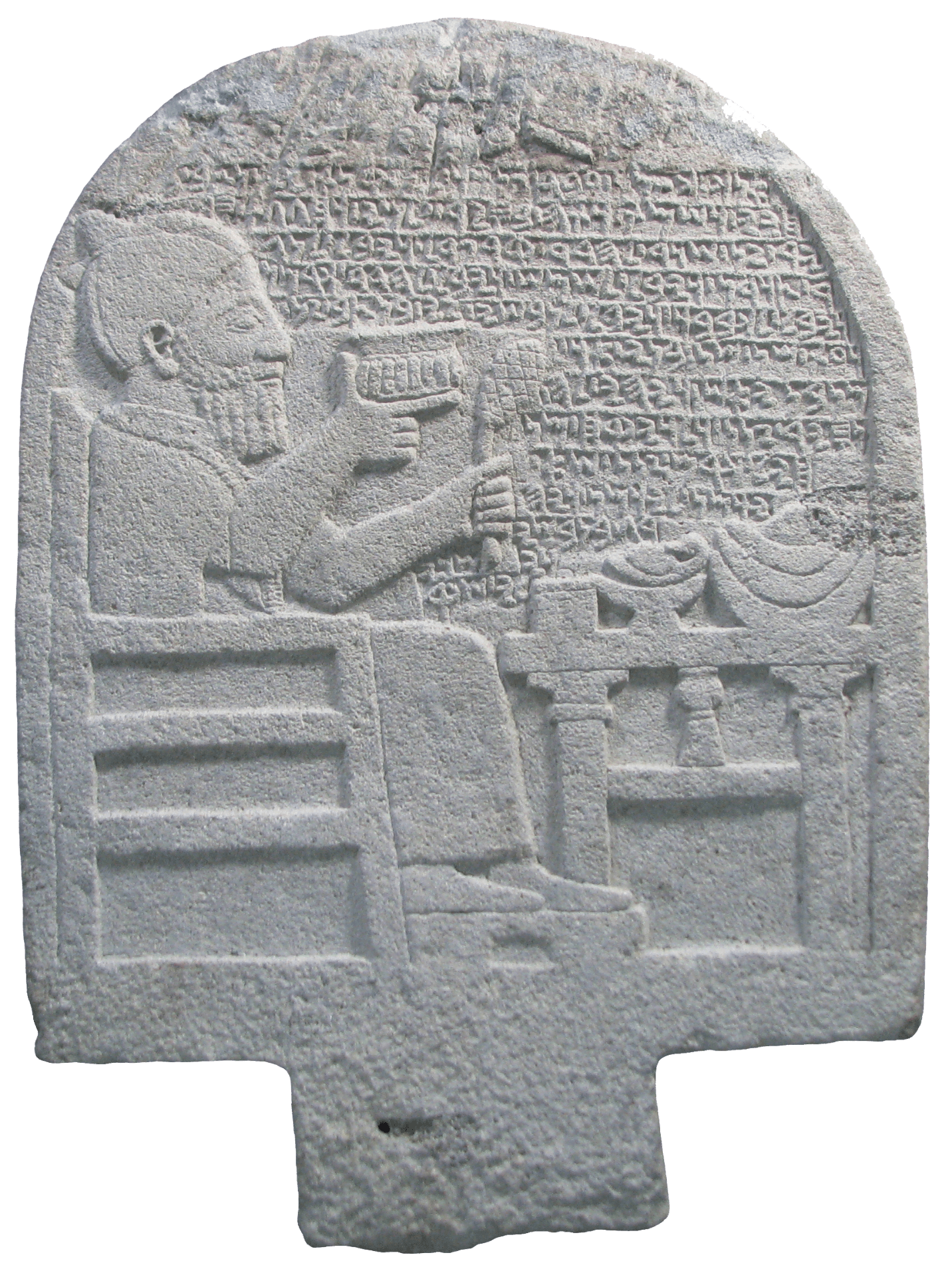
A number of noteworthy finds have been unearthed in recent years. For example, in July 2008 an inscribed pictorial stele commemorating a royal official, “Katumuwa, servant of (King) Panamuwa,” was found in a residential area in the lower town of Iron Age Sam’al. This important discovery, shown on the right, reveals new aspects of ancient religious belief and practice and was reported in the New York Times and in Archaeology magazine.
The Katumuwa Stele
The Katumuwa Stele, a pictorial mortuary monument carved from a large piece of basalt, was discovered in situ in our 2008 excavation season, within a few days of opening the first trenches of Area 5. Its rounded top was only about 10 centimeters under the modern surface. Its image and inscription provide an intriguing glimpse of the religious and social life of the Syro-Hittite cities of the Iron Age Levant. The uppermost part of the stele, where a winged sun-disk surmounted the carved portrait of the deceased Katumuwa and his inscription, was heavily scarred by metal plowshares that had scraped across it in modern times during the plowing of the agricultural field in which it lay. However, the 13-line inscription and the remainder of the image were spared any damage.
The stele’s inscription, taken together with the iconographic elements of the image of the deceased that is carved upon it and, crucially, its well-documented archaeological context, provide substantial new information concerning the beliefs underlying the Syro-Hittite mortuary cult, the mechanics of its practice, and the social background of its participants. The Katumuwa Stele enables us to reconstruct key elements of the annual feast held in honor of the deceased based on his first-person description of it. It is an evocative illustration of the way in which identity and memory were maintained via the material practices of an ancestor cult of a kind practiced widely among the various cultures of the ancient Near East (Herrmann and Schloen 2014).
Iconography and Inscription
The Katumuwa Stele is one of a number of mortuary monuments found in the Syro-Hittite region that show a banquet scene (Bonatz 2000). Some of the other examples also bear inscriptions, but the inscription carved on the Katumuwa Stele is particularly long and gives unprecedented information about the accompanying cult and rituals. Moreover, this is the only mortuary stele from this period that was excavated in its original archaeological context, providing us with valuable new information about the urban architectural setting of Syro-Hittite mortuary cults.
The stele is approximately a meter tall and is made of fine-grained gray basalt (Struble and Herrmann 2009). The image and inscription on it are carved in raised relief. Its top is rounded into an arch-like shape, its back is convex, and a square tenon protrudes from the bottom to anchor it in the ground. The damaged winged sun-disk at the top can be discerned from a few remaining traces of the carved feathers. This was a common symbol of the sun-deity, but also of other gods, in the Iron Age Levant. The rest of the scene shows a man seated in a high-backed chair with his feet on a low footstool. The man, with a full beard but apparently no hair on his head, wears a peaked cap with a tassel, a short-sleeved, ankle-length tunic, and a fringed shawl over his shoulders. He holds up a wide cup with gadrooned sides in his right hand and a conifer cone on a branch in his left hand. On a table before him are laid out a small cylindrical box (pyxis), perhaps for oil or another condiment, a duck or goose on a footed platter, and a stack of flatbreads in a bowl.
The banquet scene was the most common iconography on mortuary monuments in the Iron Age Near East, showing the deceased partaking of food and drink offerings provided his or her descendants. Bread and a drinking cup are the most common elements of these scenes. The Katumuwa Stele provides some indications of the deceased’s status via his clothing, which distinguishes him as a royal courtier, his elaborate drinking cup, and the cylindrical pyxis set on the table before him. The stele also depicts symbols of personal or religious significance, such as the conifer cone and waterfowl. This is the only mortuary stele we possess that shows a conifer cone, which was a widespread symbol of fertility in the ancient world and may have had a special significance in Sam’al because of the famous forests of cedar, pine, and fir blanketing the nearby slopes of the Amanus Mountains.
The 13-line inscription, carved in relief in alphabetic script, fills the space above the table (Pardee 2009; 2017). Whereas some inscribed mortuary steles mention that relatives of the deceased commissioned the manufacture of the stele, Katumuwa says that he commissioned it for himself while still he was still alive. His inscription goes on to describe an inaugural sacrifice and feast that took place either when the stele was installed or at the time of his death. This entailed the sacrifice of a bull to Hadad Qarpatalli (a version of the storm-god), and one ram each for NGR/D ṢWD/RN (perhaps a hunting deity), Šamš (the sun-deity), Hadad of the Vineyards (a god of wine), Kubaba (the goddess of Carchemish), and the “soul” (NBŠ) of Katumuwa himself.
This list of deities differs from the pantheon of the kings of Sam’al and includes Luwian deities. The sacrifice for Katumuwa himself is said to be for “my soul that (is/will be) in this stele.” This is the first written confirmation that mortuary monuments such as this were thought to be inhabited by the “soul” (the part of the person that remained after death) in order to receive postmortem offerings. In later periods, the West Semitic term NBŠ or NPŠ (Hebrew “nefesh”) came to be synonymous with the monument or tombstone itself in its function as representing the dead; but in this inscription, there is still a distinction between the stone stele and the “soul” present within it. Just as in royal mortuary inscriptions from Sam’al, simultaneous offerings for a list of deities and for the “soul” of Katumuwa comprise a common meal between the gods and the dead. This was previously thought to have been a privilege of royalty, representing the “deification” of the deceased. Katumuwa’s invocation of this privilege suggests either that it was available to anyone who could afford such sacrifices or that he was emulating royal behavior. The rest of the inscription requests the annual repetition of this sacrifice, or a smaller version of it, by a descendant or future owner of the building (mortuary chapel) in which the stele had been installed.
Archaeological Context
The Katumuwa Stele was found standing upright in the corner of the innermost room of Building A/II in Complex A of Area 5 (Phase 2c) (Struble and Herrmann 2009; Herrmann 2014a, b, c). This room had previously been used as a kitchen. It once had two bread ovens, but when the stele was installed, the ovens were put out of use and new walls were constructed to narrow the room and its entrance. The stele was framed by a small flagstone pavement in front, a low stone bench to its right, and a stone “pedestal” to its left. These modest features likely served as the immediate setting for food and drink offerings. Five stone bowl fragments found in this room and the vestibule before it suggest the use of such vessels in the cult. No human remains were found below the stele or anywhere else in the vicinity, indicating that the pictorial stele served as a substitute for the body for the purpose of receiving food and drink offerings.
Building A/II possessed three more rooms of similar size and was fronted by a walled forecourt. When the building was renovated in the seventh century BCE, it was fairly well cleaned out, leaving few features and artifacts to inform us about the function of these rooms. However, the removal of the building’s earlier domestic features and the use of the word SYD in the inscription to describe the stele’s location, which probably means something like “reception hall” (Mazzini 2009; Sanders 2013), suggest that A/II was a special-purpose building meant to host the mortuary cult rather than a typical residential building. Someone of Katumuwa’s wealth and status would likely have lived in a larger and grander house, such as Building B/I across the street from the mortuary chapel.
The inscription mentions that the annual sacrifice was to be supported by the produce or proceeds of “this vineyard,” suggesting that there was a vineyard close by that was part of the property that included the mortuary chapel. Our geomagnetic survey of the lower town shows that there was sufficient open space for an urban vineyard to the east or south of Complex A.
But if Building A/II was not Katumuwa’s house, why was the stele located there, in Complex A? The answer is perhaps given by the building next door, the small Building A/III. Despite its small size, A/III is well built and contained two stone bases, a bench foundation, and a large fragment of a hewn stone “table” with a shallow rectangular depression covering its upper surface. These features and architectural comparisons with non-monumental shrines of the Late Bronze and Iron Age Levant indicate that Building A/III was a neighborhood temple, possibly dedicated to the first deity mentioned in the stele’s inscription, Hadad Qarpatalli. The patterning of animal bones in the vicinity of the temple also suggests the deposition of sacrificial remains, as the sacred right-side parts of animals for the consumption of gods and priests were more likely to be deposited in the interior courtyard behind the temple, while the left-side parts for consumption by lay people were discarded in the street outside the temple and plaza next to Building A/II (Marom, forthcoming; Herrmann 2014a). The juxtaposition of this neighborhood temple and adjoining mortuary chapel is consistent with the evidence of the inscription and with other textual and archaeological evidence concerning the mediation of the cult of the dead by the gods in the Iron Age Syro-Hittite kingdoms. We can imagine that the large inaugural sacrifice and feast, sufficient to feed hundreds of people, and the more modest annual offerings, supported by the endowment of the vineyard, would have allowed Katumuwa and his family to advertise their status, wealth, and piety by sharing food in his name with the inhabitants of this neighborhood.
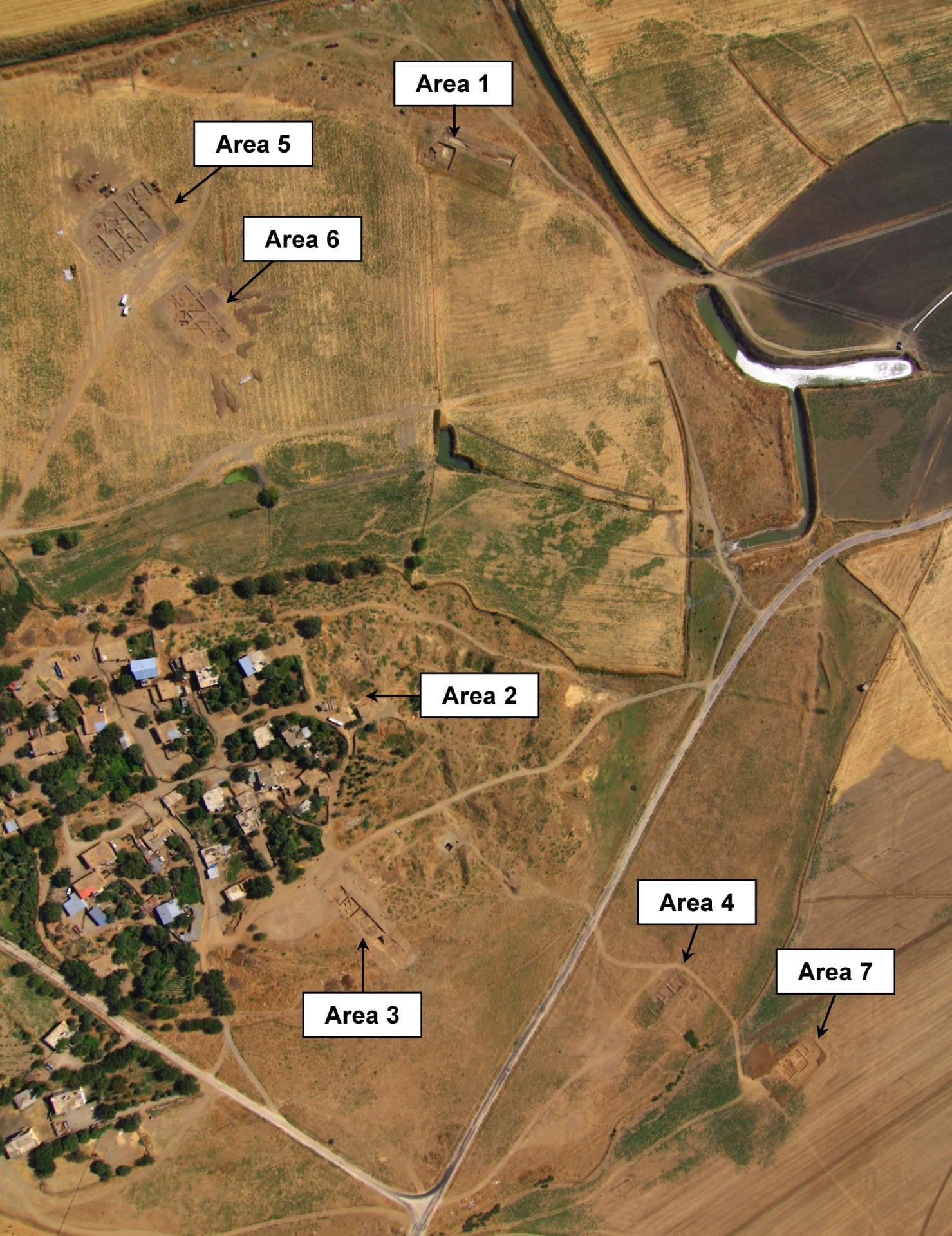
As of 2018, we have exposed a total of 7,000 square meters in ten excavation areas in and around the lower town and on the upper mound (labeled Areas 0 to 9 in the site map below). We have also carried out smaller soundings in a few other locations, as well as subsurface surveys via geophysical remote-sensing using a magnetic gradiometer, ground-penetrating radar (GPR), and electrical resistivity tomography (ERT). The geomagnetic survey, in particular, has encompassed a little more than half of the lower town (ca. 200,000 square meters), wherever it is not obscured by modern houses, trees, and roads. This survey revealed the latest phase of architecture in remarkable detail.
Digital Recording Methods
All information is recorded digitally as we excavate, using a laptop computer for data entry (one for each 10-by-10-meter excavation square) and a barcode printer to print adhesive labels bearing a unique QR scan-code for tracking every pail of pottery and every artifact or other small find. The data recorded on site is uploaded to a central database at the University of Chicago at the end of each day.
Plans and section drawings are also done digitally. A quadcopter (drone) equipped with a digital camera is used for aerial photogrammetry to produce orthorectified photomosaics (using Agisoft PhotoScan) every few days, or as often as needed, creating a detailed photographic record of the progress of the excavations. These photomosaics are subsequently georeferenced and traced in ArcMap to create highly accurate vector plans of each excavated feature, debris layer, and small find, which can be individually displayed or hidden or styled, and can be overlaid on the photomosaic raster layers. Section drawings are also done digitally using a digital camera and PhotoScan to make photomosaics of the vertical soil profiles, in which the features and layers are then outlined to make publishable vector drawings. Total stations are used to determine the exact coordinates of grid stakes and control targets used for georeferencing the photomosaics. In addition to mapping excavated features, digital maps of subsurface features are created in our geophysical surveys (e.g., the geomagnetic map of the lower town) and are stored as raster layers in our database within the same coordinate space as the plans of excavated features and layers.
Field photographs, object photographs, illustrations of objects and pottery, and descriptions of registered small finds are also made digitally and uploaded regularly to our central database in Chicago, where they are linked to the relevant excavated features and debris layers and their georeferenced vector and raster map layers. The Zincirli database is stored and managed within the OCHRE database platform built by Sandra Schloen, which is used by a number of archaeological projects in the Middle East and elsewhere.
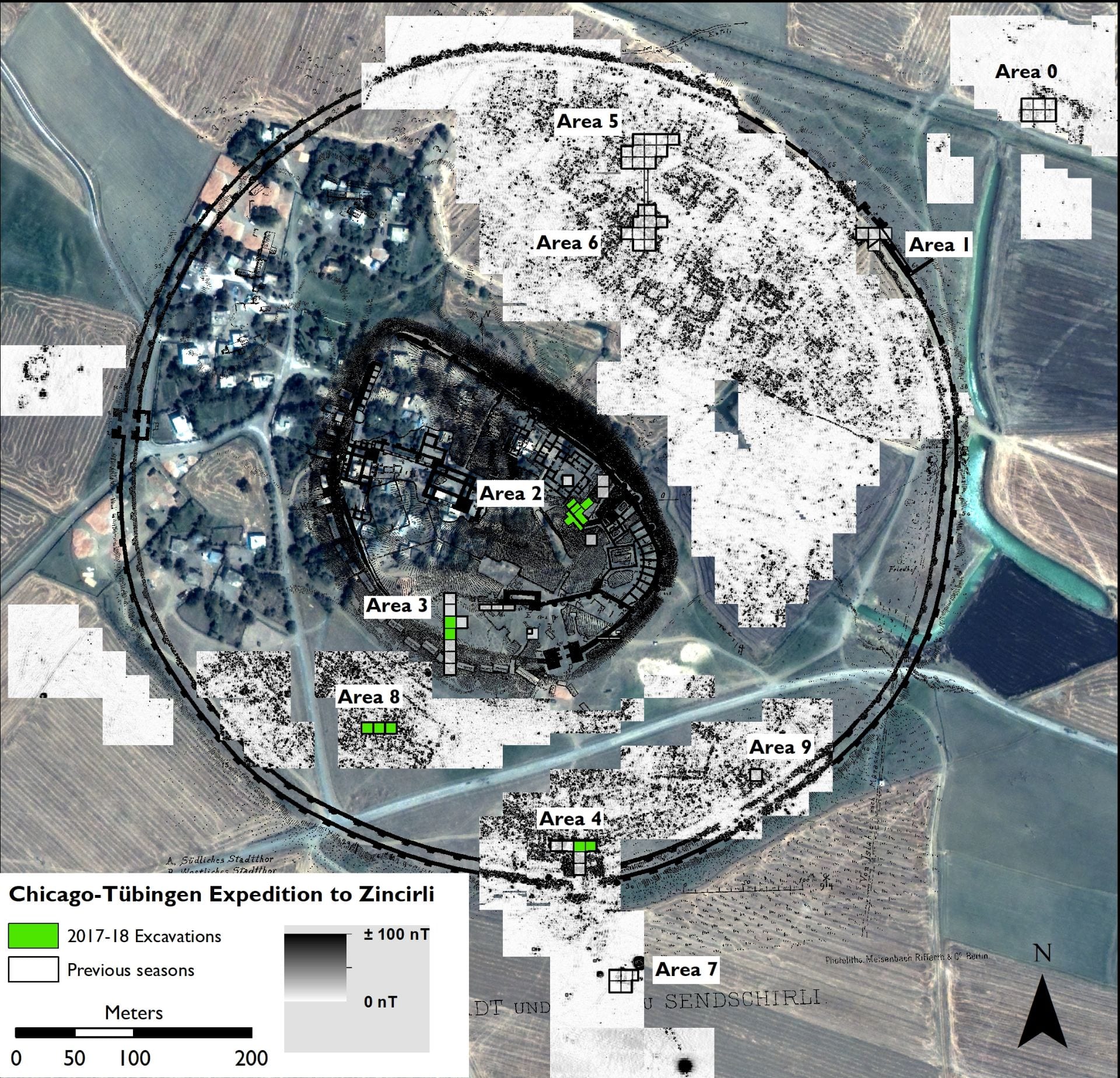
Map of Zincirli showing the ten current excavation areas, which are divided into 10-by-10-meter squares. In this map, the geomagnetic survey results in the lower town and the architectural plan made by Robert Koldewey for the German expedition in 1894 are both superimposed on a modern satellite image of the site.
The results obtained in each excavation area (as of October 2018) are summarized below. Some of these results are still preliminary, so the interpretations presented here are subject to change as new material is excavated and studied. We have excavated two areas on the upper mound (the royal citadel of the Iron Age): Area 2 in the Eastern Citadel and Area 3 in the Southern Citadel. Three areas have been excavated in the southern part of the lower mound (the Iron Age lower town south of the royal citadel): Area 4, just inside the South Gate; Area 8 in the Southwestern Lower Town; and Area 9 in the Southeastern Lower Town. Three areas have been excavated in the northern part of the lower town (north of the royal citadel): Area 1 beside the Northeast Gate; and Areas 5 and 6 in the Northern Lower Town. Finally, two areas have been excavated outside the outermost wall of the Iron Age city to investigate extramural buildings revealed in our geomagnetic surveys: Area 7, 60 meters south of the South Gate; and Area 0, 150 meters north of the Northeast Gate. Taken together with the results of geophysical remote sensing, our excavations in diverse locations across the site allow us to form a relatively complete and accurate picture of the development of the ancient city and the lives of its inhabitants.
Area 0: The Extramural Building (kāru?) in the North
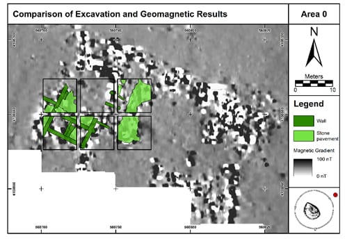
A geomagnetic survey conducted in 2009 showed the existence of a large rectangular building (ca. 55 meters by at least 37 meters) outside the city in what we have called Area 0, about 150 meters north-northeast of the Northeast Gate. A total area of 600 square meters was excavated in Area 0 over two seasons in 2010 (supervised by Eudora Struble) and 2013 (supervised by Christoph Bachhuber). Part of the extramural building was exposed and information was collected to determine its date and function. It had a single architectural phase dating to the late eighth and/or seventh century BCE, in the period after the Assyrian takeover of Sam’al. It consisted of small rooms surrounding a series of large, cobble-paved courtyards. The central courtyard had a stone column base and this, together with a few blue-green glazed ceramic fragments that resemble the glazed wall funnels (Rohrringe; see Soldi 2009) excavated previously on the citadel near Hilani III and Hilani IV, suggests that the building had a public function. The remnants of this structure are close to the modern surface, in a plowed field, so few artifacts were preserved, making it difficult to say more about its function. However, one room of the building contained fragments of a few large ceramic storage jars, and other notable finds include an iron saw fragment and a few spindle whorls, loom weights, and stone grinding tools.
The layout of this extramural building and its location just outside the city, apparently facing the road that led up to the Northeast Gate, suggest that it was a trading station or customs house (Akkadian kāru or bīt kāri). Travelers coming from the direction of the Euphrates River would have had to pass by it to enter the city. Neo-Assyrian inscriptions tell of trading stations established at strategic points around the empire, especially at the frontiers, in order to regulate trade with vassals and allies and in some cases to collect tribute (Yamada 2005). We cannot say for certain, however, whether the building in Area 0 was constructed by the Assyrians or was built earlier by the kings of Sam’al.
Area 1: The Northeast Gate
The German expedition traced the outer and inner fortification walls of the Iron Age lower town and the three large gates that were set into these walls: the South Gate, the West Gate, and the Northeast Gate. The edges of the outer part of the Northeast Gate were traced and its threshold, in which were two stone door-sockets for the wooden gates, was excavated. Of the inner part of this gate, only the threshold, lined by undecorated stone orthostat slabs, and one of the flanking towers were excavated; the rest of the plan was extrapolated (von Luschan, Humann, and Koldewey 1898: 116, plate 12). The West Gate is under a modern road intersection and inaccessible to us, and the South Gate was fully excavated by the German expedition, so we decided to explore an unexcavated portion of the Northeast Gate to check the stratigraphy of the fortifications and the relationship between the gate and the massive walls into which it was integrated.
In 2006, we excavated 45 meters of the outermost city wall adjacent to the Northeast Gate, on its east side, revealing details of the construction technique and demonstrating that the massive wall was founded on virgin soil where no earlier buildings existed. It was built in the midst of Iron Age agricultural fields a few hundred meters from the original settlement mound, which now served as a royal citadel. One or two courses of large basalt foundation stones were set into a trench below ground while the rest of the outer wall’s foundation rose above ground level to a height of 3 meters. The total height of the wall, including the mudbrick superstructure (now eroded away), is impossible to determine, but an estimate of at least 10 meters is quite reasonable.
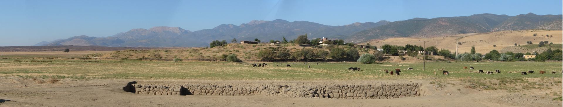
The exterior face of the stone foundations of the outermost city wall, immediately adjacent to the Northeast Gate (not excavated), after excavations in 2006 that exposed a 45-meter section of the wall. The foundations of two rectangular towers projecting outward from the wall are visible; the one on the left is intact, while the one on the right has collapsed.
A 250-square-meter portion of the Northeast Gate’s tower foundations, inner chambers, and flagstoned entryway was excavated in 2007 (supervised by Virginia Herrmann). In 2008 and 2009, the corridor between the outermost wall and the matching concentric wall, built 7 meters farther in, was exposed (supervised by Christoph Bachhuber and Tuğba Gençer). In 2016, a sounding was made below the inner gate tower foundation to obtain material with which to date its foundation, revealing further details concerning the construction method (supervised by Virginia Herrmann).
Excavations in Area 1 showing the foundations of the inner and outer walls, 7 meters apart, and a portion of the Northeast Gate’s foundations (on the right).
It appears that the inner and outer walls of the lower town fortifications were built at the same time, together with the gate, with which they are seamlessly integrated according to a coherent architectural plan. This is contrary to the opinion of the previous excavators, who believed that a difference in construction technique between the two walls (the inner wall had much shallower foundations consisting of smaller stones, into which transverse wooden timbers were inserted) was an indication that they were built centuries apart. But the difference in technique is more likely the result of the different functions of the two walls, because the deeper and more massive foundation of the outer wall was needed in order to withstand battering rams and undermining, while the inner wall’s foundation served only to support a mudbrick superstructure on which the inner ring of defenders could stand. At some point during the use of the Northeast Gate, reinforcing features were added to the inner gate tower. A fire seems finally to have ended the life of the gate, as shown by burnt bricks collapsed on the floors of the gate chambers.
In 2009, we dug an exploratory trench 30 meters long and 2.5 meters wide that extended northeastward from the exterior face of the outermost city wall and perpendicular to it. The purpose of this trench was investigate the possibility of a moat or other fortification elements outside the wall. Not far below the modern surface we found a 2-meter-wide sloping stone feature or retaining wall at a distance of 9 meters from the city wall and running parallel to it. The high water table in this area, due to the proximity of the wall to a seasonal watercourse that flowed down from the mountains to the west along the north side of the Iron Age lower town, suggests that this sloping stone feature was designed to divert floodwaters away from the city wall so they would not be undermined. It may have bounded a water-filled moat fed by the seasonal runoff and so served a defensive purpose in addition to protecting the wall from the flowing water; however, we did not find a parallel retaining wall on the other side that would have confirmed the moat hypothesis.
Area 2: The Eastern Citadel
Since 2007, we have excavated several trenches in Area 2, in the Eastern Citadel on the east side of the upper mound. These trenches were placed in various locations, ranging from the summit of the upper mound, where the Assyrian-period Palace G and earlier Hilani I had been excavated by the German expedition, down to the lower terrace of the upper mound, southeast of its summit.
Excavation areas on the eastern side of Zincirli, showing the placement of Area 2 (the Eastern Citadel) in relation to Area 3 (the Southern Citadel). These areas are accessible for excavation because they are not occupied by the modern village, although Area 2, in particular, was previously excavated on a large scale by the German expedition, requiring us to work in and around their trenches.
In 2007, our excavations at the foot of the slope, southeast of the summit (supervised by Christoph Bachhuber), investigated a large basalt sculpture that was reported to us by residents of the Zincirli village. This sculpture bears the roughed-in outline of the face and forelegs of a lion standing 1.5 meters tall. Its size and schematic character, lacking as it does the finer details that would have been carved or painted after its initial shaping, make it closely similar to the many lion protomes found at the Yesemek sculpture quarry located 23 kilometers south of Zincirli. It is likely that this sculpture was brought to Zincirli from that site and, for some reason, its carving was never completed. It was found head-down in an undocumented German trench, having been re-exposed by the villagers. Unfortunately, therefore, its context was badly disturbed and its original placement and stratigraphic position remain unclear.
Two more exploratory excavations (both supervised by Christoph Bachhuber) were conducted on the summit of the upper mound in 2010 and 2013. In 2010, we explored the massive stone foundations in the center of Hilani I that had previously been exposed by the German expedition, in the hope of finding evidence concerning the Early Bronze Age strata that lie beneath this deeply founded structure and must have been cut by it. In 2013, we explored the stratigraphic relationship between Hilani I and the Iron Age citadel wall (Burgmauer) that ran along the northeastern edge of the upper mound. Although we found the citadel wall where we expected it to be, the corner of Hilani I was missing in this location.
In 2012, we began digging a stratigraphic step-trench down the steep slope of the upper mound, southwest of Hilani I, in a location where the ancient remains had been less disturbed by previous excavations. This step-trench is 4 meters wide and 20 meters long. It extends from our 2007 trench at the foot of the slope, southeast of the summit, northward up the slope to the present-day summit of the upper mound. Excavations in this step-trench in 2012 and 2013 (supervised by Yağmur Heffron) revealed fragmentary Iron Age features that were much disturbed by later activity and slope erosion. In 2013, the step-trench was widened at the flat top of the mound to a width of 8 meters in order to get a better view of the Iron Age architecture, which we found to be poorly preserved. An important find during the 2013 season was a fragment of hippopotamus ivory on which was incised a short Hieroglyphic Luwian inscription. This attests to the ongoing use of Luwian in Iron Age II Sam’al, where monumental inscriptions were written exclusively in Northwest Semitic languages, albeit carved in raised relief in the earlier Luwian style of the Iron Age I.
Continued excavation in the step-trench in 2015 (supervised by Kathryn Morgan) reached better-preserved remains below the erosional material and later disturbances. Two rooms of a burnt building dating to the Middle Bronze Age were uncovered, one of which contained forty complete ceramic vessels, as well as a clay figurine of a nude female and a seal-impressed clay bulla. Among the vessels were large spherical jugs with red and black painted decoration of a type that has been found at the central Anatolian site of Kültepe (ancient Kanesh), the location of an Old Assyrian trading colony, and at sites near the Euphrates River. The destroyed Middle Bronze Age building was later cut by a stone retaining wall built in the Iron Age II on its southwestern side. By then, the Middle Bronze remains were eroding out of the side of the mound and the Iron Age wall shored up the slope and prevented further erosion.
The discovery of a well-preserved Middle Bronze Age stratum at Zincirli was an exciting development, with the potential to reveal connections to the Middle Bronze Age palatial center at nearby Tilmen Höyük, 8 kilometers to the south, and to the long-distance trade networks that spanned the Near East in this period. In 2017, we widened the Area 2 step trench toward the north by 10 meters in order to connect it with Hilani I. The enlarged trench now overlapped the area of Palace G, the Assyrian provincial-period palace of Sam’al, which had been fully excavated and removed by the nineteenth-century German expedition. However, Hilani I, the massive earlier structure below the northern part of Palace G, had not been removed. To our surprise, we found that the destroyed Middle Bronze Age stratum lay undisturbed directly beneath the present-day surface, which corresponds to the bottom of the Palace G trench of the previous excavations, where the German excavators had removed several meters of material from the top of the upper mound. We had expected to find disturbed Iron Age remains in this area from the period before Palace G, but these had all been removed by the earlier excavators or by the modern villagers who lived in this area after the German excavations were completed. They had stopped just above the Middle Bronze Age destruction layer, which was thus well preserved with only a few later intrusions.
In 2017, we widened the exposure by several meters and uncovered two rooms of a monumental Middle Bronze Age building that lay northeast of the original step-trench. This building was separated from the previously discovered building to the southwest by a narrow street, on which dozens of pyramidal clay loom weights had been spilled or had fallen at the time of the destruction. Additional complete storage jars and globular jugs, as well as seal-impressed clay bullae and cylinder seals, were found in the monumental building. A third room of the previously discovered building across the street to the southwest was excavated, revealing more complete vessels, a bronze figurine, and a needle case made out of a hollow bone and still containing bronze needles.
In the same season, beneath two stone-lined drains dating to the Iron Age, we exposed a previously unexcavated portion of the stone foundation of Hilani I near the northeastern edge of our trench. Here we found that the burnt destruction debris from the Middle Bronze Age buildings lapped up to and ran over top of the foundation stones of Hilani I. This was a surprise, because it proves that Hilani I was constructed, not in the Iron Age, as previously believed, but a thousand years earlier during the Middle Bronze Age. This new result calls for a re-evaluation of Hilani I and of the origins of the hilani architectural form. The presence of such a monumental building in Middle Bronze Age Zincirli also suggests that this site was a more significant center in this period than had previously been thought.
Area 3: The Southern Citadel
Area 3 in the Southern Citadel lies in the south-central part of the upper mound. Most of our excavations in this area have been done in a long trench, 10 meters wide and 70 meters long, that is oriented north-south across the southern edge of the upper mound, from the foot of the Iron Age citadel rampart up to the flat surface of the upper mound. This part of the site, west of the Citadel Gate, was previously unexcavated and is thus a prime location for applying modern archaeological methods to investigate the two-thousand-year sequence of architecture and pottery at Zincirli, and to re-investigate the fortifications of the Iron Age citadel. Excavations were conducted here in 2007 (supervised by Amir Fink); 2008 (Robert Mullins); 2010 and 2012–2013 (Vincent van Exel); 2015 (Elizabeth Bloch-Smith); and 2017–2018 (Barbara Bolognani). In this trench, we have found remains dating to the Early Bronze Age IV (2500–2000 BCE); the Iron Age II (900–750 BCE) and Iron Age III (750–600/550 BCE); and the late Persian and early Hellenistic periods (fourth–third centuries BCE).
In 2008, in the course of excavations in this long trench, a deep section was cut through the Iron Age earthen rampart. At the base of the rampart was a mass of fired bricks that belong to the original settlement of the site in the third millennium BCE, judging by the pottery found at this level. Above this Early Bronze Age destruction layer is a thick earthen rampart constructed in the Iron Age II. It was built directly on top of the Early Bronze Age stratum, creating a higher and steeper slope to protect the Iron Age royal citadel and ward off attackers. We initially suspected that this rampart dated to the Middle Bronze Age, but it seems now that the Middle Bronze Age buildings and fortifications were set back farther toward the center of the upper mound, where we have found them in Area 2, and did not extend this far south. The Iron Age rampart was faced with a stone glacis. At the top of the glacis there was a large wall, three meters in width. The stone foundations of this wall, which were three courses high, originally had large wooden beams inset into them and placed transversely across the stones for added strength, using the timber-grid (Balkenrost) technique employed also in the lower town fortifications. The wooden beams themselves have long since decayed but have left regularly spaced linear gaps in the stone foundations.
This wall is similar in construction to the citadel wall (Burgmauer) found by the German expedition. However, the wall we found in Area 3 does not belong to the earliest phase of Iron Age II fortifications but was an eighth-century BCE reconstruction of the Burgmauer, which had been entirely removed in this location, perhaps because it had become too damaged or dilapidated. We found no trace of the earlier wall but only indirect evidence for its existence, in the form of structures that underlay the later wall and must have run up to the earlier wall. The Burgmauer of the German expedition showed traces of repair and modification in various places around the perimeter of the citadel, so it seems likely that the original citadel wall of the late tenth or early ninth century BCE was not completely replaced everywhere, as it was in Area 3, but in some cases was only repaired.
Our excavations on the top of the upper mound in Area 3 uncovered structures belonging to seven different architectural phases, from the Iron Age II to the early Hellenistic period. We have so far uncovered only a few wall segments belonging to the earliest phase of the Iron Age II, but in the next Iron II phase we excavated a building consisting of at least two long rectangular rooms, one of which contained a rectangular silo with a mud-plastered lining that was flanked by a mudbrick bench on one side and a mudbrick platform on the other. After the abandonment of this building, the area seems to have been intentionally kept open or was little used for a period of time in the eighth century BCE, because in that phase we found only erosional accumulation and pits, including a large cylindrical trash pit containing many layers of ash and animal bones.
In the next phase, which we can place in the early Iron Age III after 750 BCE, the area was completely renovated. There was a complete replacement of the citadel wall in Area 3, as mentioned above, and the construction of several buildings that contained small bread ovens. These houses were separated from the citadel wall by a paved street with a stone-lined drain running down the center. Sometime later, probably during the Assyrian provincial period in the seventh century BCE, this street and houses were replaced by a small temple, of which only the western half has been excavated. This temple is bipartite and roughly square in plan, with two successive broadrooms, similar to the extramural temple excavated in Area 7 south of the South Gate.
The walls of the seventh-century temple in Area 3 were reused in the renovation of the area that took place in the fourth century BCE, when a large building with a paved courtyard was constructed. Several large storage jars were found in a room of this building. The upper mound was refortified at this time with a new wall, whose stone foundations also contained transverse slots for wooden beams. It is not yet clear whether this new construction and fortification at Zincirli took place near the end of the Achaemenid Persian Empire or at the beginning of the Hellenistic period under Alexander the Great or one of his successors. Three coins attest to the occupation of this area in the late fourth and early third century BCE: a bronze coin of Alexander’s half-brother Philip III Arrhidaeus (323–310 BCE); a gold stater bearing the head of Alexander the Great; and another bronze coin. The latter two were minted by Seleucus I Nikator (312–281 BCE), the founder of the Seleucid Empire.
In addition to our main trench in Area 3, which extends 70 meters from north to south and runs down the slope of the upper mound, we have excavated three smaller trenches nearby in the Southern Citadel. One of these trenches was placed 20 meters east of the main trench, where it overlaps the previously excavated inner gate (Gate E) that led from the protected zone inside the Citadel Gate into the royal precinct on the highest part of the upper mound. This trench is 5 meters wide and 30 meters long and is oriented at right angles to the main trench, running east-west rather than north-south. It was excavated in 2012 (supervised by Elizabeth Bloch-Smith) and in 2013 (supervised by Vincent van Exel and Simon Halama) in order to re-investigate the stratigraphy of Gate E, with the goal of eventually connecting up with our main trench to the west. The remains of Gate E and the internal cross-wall in which it was set (the Quermauer), as well as a structure below Gate E (the Alter Bau), were investigated and we learned that they lie on top of a burnt destruction layer of the Middle Bronze Age. This destruction layer is probably contemporary with the Middle Bronze Age II destruction found in Area 2 in the Eastern Citadel.
Another exploratory trench (supervised by Christoph Bachhuber) was excavated in 2010 north of the Citadel Gate beneath the so-called Lions’ Pit, where five huge gate lions of the Iron Age II, carved in stone, had been found by the German expedition, buried in a thick layer of ash. We hoped to find evidence here concerning the early history of the site and we excavated quite deeply, but found no Bronze Age remains in this location, suggesting that the area inside the Iron Age Citadel Gate and below the inner gate (Gate E) was not part of the original Bronze Age mound. The mound had been expanded to the southeast in the Iron Age II, when it was fortified (or re-fortified) as a royal citadel.
In 2013, another small trench was dug across the citadel wall on the southeastern edge of the mound (supervised by Vincent van Exel and Martin Weber). The walls of small Iron Age structures earlier than the citadel wall were encountered in this trench, so it is likely that here, too, the original Iron Age citadel wall had been removed and replaced, as it was in our main trench farther west in Area 3.
Area 4: The South Gate
The South Gate, the main and largest gate giving access to the lower town, was excavated in the first season of the German expedition in 1888. Eight relief-carved orthostats were found that had once lined the façades on both sides of the inner gate passage. In 2007, excavations began in Area 4 (supervised by Robert Mullins), in an east-west trench that initially measured 10 by 40 meters and ran a few meters north of the South Gate, just inside the lower town and parallel to the city wall. Our goal here was to investigate the street leading from the South Gate to the Citadel Gate and to examine the structures that flanked this street. As expected, just below the modern surface we found a stone-paved street that ran northward into the city from the South Gate. This was the last phase of the street before the final abandonment of the lower town at the end of the seventh century BCE. To the east of the street was a paved open courtyard. Its west side was flanked by a row of small rooms whose purpose is unknown. Farther west, across an open space, we exposed part of a courtyard house dating to the seventh century BCE in which a cylinder seal carved in the Neo-Assyrian style was recovered.
In 2012, 2013, and 2015, we conducted additional excavations in selected parts of the Area 4 trench (supervised by Marina Pucci) and expanded the trench southward, with the goal of making a stratigraphic connection to the South Gate itself. Further excavations were conducted in the eastern half of the Area 4 trench in 2017 (supervised by Laura Malric-Smith) and in 2018 (supervised by Charles Wilson). These various excavations have allowed us to determine the stratigraphic relationship of the South Gate to the architectural phases of the lower town (Pucci 2015). It is now clear that there was a period of abandonment prior to the last paving of the street in the seventh century BCE. This is one of several indications that Zincirli suffered a major disruption and partial or complete abandonment during the first half of the seventh century BCE. Following this abandonment phase, the gate itself remained in a dilapidated condition and was never repaired, although the rebuilding of the street shows that people still entered the city at this location, perhaps through a smaller gate that is no longer preserved, built on the ruins of the original South Gate, whose carved orthostats were probably buried in rubble at this point.
During the temporary abandonment phase, an individual was buried in the street inside the gate with grave goods that can be dated to the Iron Age III: a dagger, several arrowheads, a fibula, and a bronze bowl. This burial was cut into the earlier street levels and provides a clear indication that this part of the site (and perhaps the whole lower town) fell out of use for some time. In the period before the abandonment phase, the original street that led into the city from the South Gate was much wider than the stone-paved street constructed afterward, when the monumental gate was not rebuilt. The width of the original street corresponds to the full width of the South Gate passageway, and was even a bit wider on the west side. East of the original street there was about 5 meters of open space, bordered by some fragmentary structures that have not yet been fully investigated. The street paving was renewed twice before the temporary abandonment phase.
A surprising result of the 2015 and 2017 seasons of excavation is that the South Gate and the original street issuing from it were founded directly on occupational remains dating to the Early Bronze Age IV (ca. 2500–2000 BCE). Scholars had previously been unaware that the site of Zincirli was occupied by a large lower town in the third millennium BCE, accompanying the long-attested Early Bronze Age remains found on the upper mound. Our excavations near the Northeast Gate and in the Northern Lower Town in Areas 1, 5, and 6 had demonstrated that, in the northern part of the site, the Iron Age lower town was founded on previously unoccupied land. However, in Area 4 on the far southern edge of the site we exposed parts of three Early Bronze Age buildings, separated by a narrow street, which lay immediately under the earliest Iron Age occupational level. These buildings were well built with stone foundations and are oriented northwest-to-southeast, running underneath the Iron Age South Gate and bearing no relation to it. The uppermost phase of the Early Bronze Age lower town is not well preserved, but there are indications of an earlier phase below it that was destroyed by fire and promises to yield better-preserved remains. Future excavation of these Early Bronze Age levels will provide substantial new information about this little-known period at Zincirli.
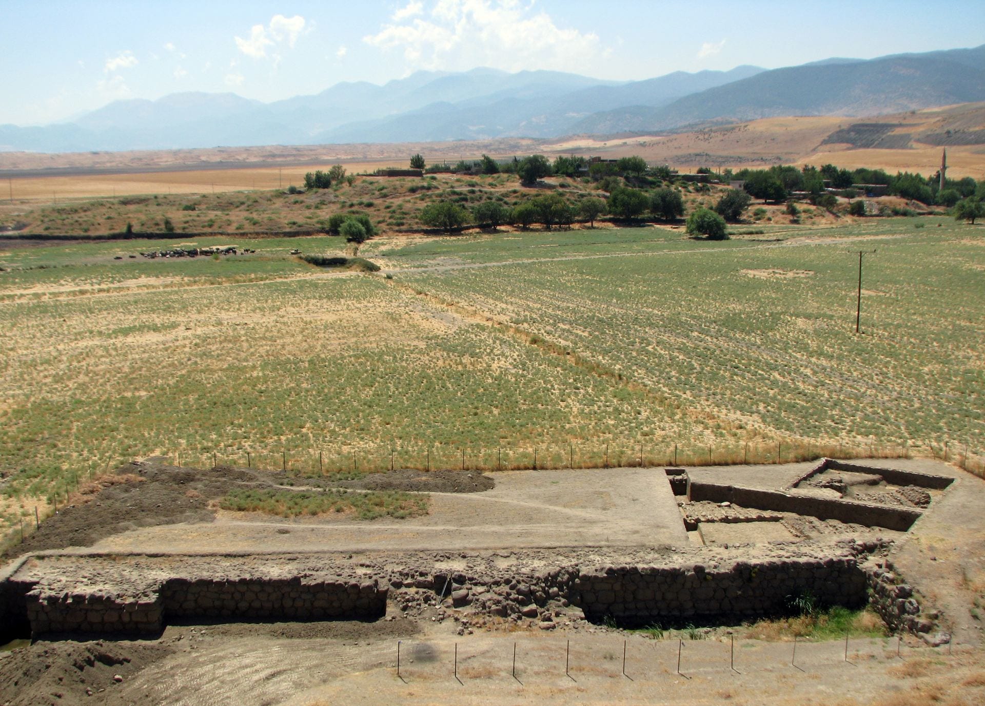
Areas 5 and 6: The Northern Lower Town
Our 2007 geomagnetic survey of Zincirli detected several large building complexes in the Northern Lower Town, just under the modern surface and widely spaced one from another. These constituted an elite residential district surrounded on both sides by much less monumental and more irregularly planned architectural complexes (Casana and Herrmann 2010). Moreover, this elite district was not an original feature of the urban organization at the time of the lower town’s settlement in the ninth century BCE. In Area 5 (Complex A, Phases 2e and 2d) and Area 6 (Complex E, Phase 4), our excavations have shown that the original settlement in the Northern Lower Town consisted of small, agglutinated buildings with an irregular plan.
The transformation and monumentalization of this part of the lower town began around 740 BCE in the reign of Panamuwa II, king of Sam’al, whom the Assyrian king Tiglath-pileser III had installed on the throne, and continued under his son Barrakib. These are the last known kings of Sam’al and both were loyal clients of the king of Assyria. After them, the royal dynasty was eliminated and the kingdom was annexed as a directly governed Assyrian province; however, the elite complexes of the Northern Lower Town continued in use, much as before, and were even renovated from time to time, until the end of the empire in the late seventh century BCE.
Excavations began in 2008 in two areas of the Northern Lower Town: Areas 5 and 6. These areas were chosen to obtain information from two different types of architectural complex detected in the geomagnetic survey. In Area 5, the geomagnetic map reveals a street, south of which were smaller, agglutinated buildings (Complex A) and north of which was a large courtyard structure (Complex B). In Area 6, about 30 meters south of Area 5, the geomagnetic map shows another large courtyard structure (Complex C).
Excavations in these two areas over several seasons have yielded substantial evidence of changes in daily life and urban organization over the course of the Iron Age II and III, from the time of the lower town’s foundation in the ninth century BCE to the period of control by the Neo-Assyrian Empire in the eighth and seventh centuries. Area 5 also yielded one of our most important and unexpected discoveries: the inscribed mortuary stele of a royal official named Katumuwa, which was carved in the 730s BCE. The text, image, and archaeological context of this stele, found in situ in a mortuary chapel adjacent to a neighborhood temple, give us a valuable chronological anchor and new information about religious beliefs and mortuary practices in the Iron Age Levant.
Area 5
The excavations in Area 5 in 2008–2010 and 2012–2013 (supervised by Virginia Herrmann) grew to encompass 1100 square meters and went down to virgin soil in selected locations to establish the full stratigraphic sequence of this area. In 2013, a long, narrow trench, 3 meters wide and 30 meters long, was excavated from Area 5 southward to Area 6 in the hope of providing a stratigraphic connection between the two areas and helping us determine the function of the wide, and apparently open, space between Complex A in Area 5 and Complex C in Area 6, where the geomagnetic map showed no buildings—a result confirmed by excavation. In general, the five seasons of excavation in Area 5 gave us important new information concerning the use of space and socioeconomic development of the city from the period of local rule to its incorporation into the Neo-Assyrian Empire as a directly ruled province, as well as evidence concerning the practice of Iron Age Syro-Hittite mortuary cults.
The geomagnetic map shows that Area 5 was bisected by the inner ring road of the lower town (Street 2), which separates Complex A to the south from Complex B to the north. Complex B, which measures 55 meters by 25–35 meters, was organized around a central courtyard. We excavated the southwestern quadrant of this complex, confirming that it was a single, well-constructed building (Building B/I) with a paved central courtyard. By contrast, Complex A, measuring 53 by 28–35 meters, of which a little more than half was excavated, comprised a number of smaller, agglutinated buildings. Our excavations revealed the gradual evolution of the same architectural complex, Complex A, through five subphases of piecemeal renovation and reuse, labeled from latest to earliest as Phases 2a to 2e (Herrmann 2011; see also Marom and Herrmann 2014; Herrmann and Schloen 2016). The earliest buildings (Phase 2e) were built directly on virgin soil. The latest phase, Phase 1, is the post-Iron Age period up to the present day, when there were no permanent structures in this area.
Throughout its occupation, most of the buildings of Complex A seem to have been residential, based on their artifact inventories (e.g., grinding stones, spindle whorls, flint and iron tools, and personal ornaments), installations (e.g., small ovens, hearths, mortars, and grinding slabs), and architectural plan. However, two of the buildings in this complex acquired a cultic character in Phase 2c, in the latter part of the eighth century BCE. The plan and unusual stone installations of Building A/III suggest that it was a small neighborhood shrine; and in the adjacent Building A/II, the installation of the inscribed stele of Katumuwa, which called for annual sacrifices in this location, made it a place for the practice of a mortuary cult (Struble and Herrmann 2009; Pardee 2009; Herrmann 2014a). The Katumuwa Stele, which we can date to the period from 743/740 to 733/732 BCE because of its description of Katumuwa as a “servant of Panamuwa (II)”—the king of Sam’al and loyal vassal of Tiglath-pileser III, king of Assyria—serves as the chronological anchor for Phase 2c. This places the earlier Phases 2d and 2e in the reigns of previous kings of Sam’al in the eighth and ninth centuries, and places the later Phases 2b–2a in the Neo-Assyrian provincial period in the seventh century BCE.
Excavation of the southwestern part of Complex B in 2008 showed that Building B/I had at least two subphases of use, which correspond to Phases 2a and 2c of Complex A, based on stratigraphic connections with Street 2. In both subphases, an open area (Plaza 1) flanked the building’s western side. In the earlier subphase, the entrance room leading in from Plaza 1 contained a square-cut stone column base. A large stone foundation in the corner room may have supported a staircase leading to a second story. The later renovations of the building in Phase 2a gave it a more open plan. In 2013, further excavation of Plaza 1 and the two southwestern rooms of Building B/I quickly reached the bottom of the building, showing that this courtyard building was constructed only in Phase 2c, well after the foundation of Complex A in Phases 2d and 2e. There was evidence of smaller structures below and beside Building B/I that seem to have been removed to make way for its construction. Our attempt to explore further beneath Building B/I to learn more about this earlier occupation were frustrated by the unusually high water table at the time.
Area 6
The excavations in Area 6 in 2008 and 2010 (supervised by Gareth Roberts) encompassed 750 square meters and exposed the latest architectural phase in this area. In 2012, additional excavations in Area 6 (supervised by Virginia Herrmann) deepened and expanded the trench. A final season of excavations in 2013 (supervised by Kathryn Morgan) expanded it yet again, resulting in a total of 950 square meters of horizontal exposure of the large courtyard structure we have called Complex C.
Area 6 was intentionally laid out along the northern part of Complex C, which was the largest architectural complex visible in the geomagnetic map of the Northern Lower Town, with an estimated area of 3600 square meters (it measures ca. 80 by 40–50 meters). The excavations exposed the entire northern unit (Building C/I) of the complex, parts of connected structures (Buildings C/II–VI), and the northern two-thirds of the large, square courtyard (20 by 20 m) to the south, which was paved with large rounded pebbles. Complex C was thus constructed of multiple discrete units arranged around courtyards of regular shape to form a unified architectural entity, much like Palace G on the citadel of Zincirli.
The plan of Building C/I (16.7 by 19.7 m, 329 square meters) matches very well the typical bīt-hilani plan, having two consecutive broad rooms with smaller side and back rooms; however, none of its floors or installations was preserved. The stone socles of the wide walls of Building C/I rise several courses above the level of the courtyards, and the lack of doorway openings suggests that they were reached by steps that are no longer preserved and that the floors would have been raised above the courtyard level as well. This means that there is little evidence remaining of the artifacts and ceramics used in the rooms. Nonetheless, the monumental character of the construction of Building C/I and its plan suggest that it served as a residence and reception/representation building. Finds and ceramics on the pebble pavement of the courtyard and in the rooms of the other buildings of Complex C lay just under the modern surface and were very sparse, and thus do not clearly indicate activity areas or room functions.
Remnants of the walls of at least two earlier architectural phases were encountered in 2010 inside the rooms of Building C/I and below their floors, but the deep foundations and filling operations for this building’s construction so disturbed the earlier strata here that it is difficult to say anything about their character or date. In 2012 and 2013, excavations beneath the pebble-paved courtyard of Complex C investigated these earlier phases in a less disturbed area and detected two earlier architectural phases above virgin soil, Phases 3 and 4, each of which could be divided into two subphases.
In the earliest phase in Area 6, Phase 4, this area was occupied by non-monumental buildings organized in an irregular, possibly agglutinative manner (Complex E). The artifacts and installations found in these rooms and courtyards, such as grinding stones, textile tools, hearths, ovens, and ceramic vessels such as bowls, plates, kraters, and storage jars, suggest a domestic context. Although the overall plan is difficult to reconstruct without broader exposures, Complex E is similar in appearance to Complex A of Area 5 in the same period and starkly differs from the formal and monumental architecture of the later Complex C.
One of the rooms of Complex E in Phase 4 had been destroyed by fire, and while this destruction was only localized, most of the other rooms were also abandoned in the subsequent phase (Phase 3). Other parts of Complex E were completely razed and cut in Phase 3 by the construction of large new walls that formed part of Complex D to the north. It is difficult to reconstruct the plan of Complex D, and no floors associated it were recovered. The stone foundations of this new structure were much larger than any of the walls of Complex E, and it seems likely that Complex E was abandoned and partially razed in order to make way for it. The now largely open areas to the south of Complex D were used primarily for trash disposal. Finally, in Phase 2, all of the Phase 3 architecture and surfaces were cut and covered by the massive construction of Complex C.
Radiocarbon dates and material culture suggest that Area 6 Phase 4 began in the ninth century BCE and continued into the early part of the eighth century, while Phase 3 can be dated to the mid- to late-eighth century, contemporary with Area 5 Phase 2c, which contained the Katumuwa Stele from the reign of Panamuwa II (ca. 740–732 BCE) and continued into the reign of Barrakib, his son and heir. The latest architectural phase in Area 6, Phase 2, cannot be dated precisely, but the similarities between Complex C and the Assyrian governor’s Palace G on the citadel of Zincirli strongly suggest that it was built during the Neo-Assyrian provincial period in the seventh century BCE. Phase 1 is the post-Iron Age period when there were no permanent structures in this area.
The Impact of the Neo-Assyrian Empire
The middle phase of architecture in Area 5, Phase 2c, spanned the reigns of the last known kings of Sam’al, Panamuwa II and Barrakib, and continued in use until sometime after the elimination of the local dynasty and the annexation of the kingdom as a directly ruled Assyrian province, which must have occurred between 725 and 713 BCE. This political upheaval, which is marked at some sites in the Levant by a major destruction, is so far invisible in the archaeological record of Zincirli, including in Area 5. Instead, we see a smooth transition from Phase 2c to 2b and from the eighth to the seventh century BCE. There is no indication of a significant disruption in the life of the city accompanying this important political event.
The biggest architectural changes in Area 5 seem to have taken place already under the last kings, who were loyal Assyrian clients (Herrmann and Schloen 2016), resulting in Phase 2c. These changes included the construction of a large courtyard structure (Building B/I), replacing earlier buildings, and the construction of the neighborhood temple (Building A/III) and the conversion of an adjoining structure (Building A/II) from domestic use to make a mortuary cult place housing the Katumuwa Stele. At the same time, there was a modest increase in the frequency of metal objects and status items such as personal ornaments, weapons, and stone vessels. New object types that appear in Phase 2c, such as bronze weights, a scale pan, a cylinder seal, fibulae of Assyrian type, and an armor scale, suggest that some inhabitants of Area 5 now had more specialized occupations as merchants, soldiers, or administrators. And, setting aside the large courtyard Building B/I in Complex B in order not to skew the statistics, the average house size in Complex A also increased. The discarded animal bones show that the animal economy became more specialized in this period, focused more on sheep and cattle at the expense of goats and pigs and with a more integrated distribution system (Marom and Herrmann 2014).
We can probably attribute these developments evident in the archaeological record to the desire of Panamuwa II and Barrakib, now backed by the overwhelming power of the Assyrian army, to centralize their control of the kingdom, gathering the leading men of the kingdom into the city to form a class of courtiers under the watchful eye of the palace. The reliefs of Barrakib depict such courtiers. They are dressed, like Katumuwa “servant of Panamuwa” (as he is depicted on his own stele)—in a simpler version of the king’s clothing. In their urban reorganization, the last kings of Sam’al would have been emulating their Assyrian overlords: the lower towns of cities elsewhere in the Neo-Assyrian Empire were typically dominated by large elite residences and other state functions rather than being occupied by non-elite neighborhoods (Herrmann and Schloen 2016).
After these dramatic changes in the urban fabric, there was relatively little change in Area 5 between the pre-provincial Phase 2c and the subsequent Phase 2b, which belongs to the early part of the Neo-Assyrian provincial period in the late eighth and early seventh century BCE. However, the late Neo-Assyrian provincial period, in the middle and late seventh century, witnessed more extensive modifications, which are attested in Phase 2a. We do not have precise dating information for Phase 2a but the changes seen in that phase probably came in the wake of the violent destruction of the old royal palaces on the citadel, which happened after 671 BCE, based on the date of a cuneiform tablet found inside one of the palaces (Faist 2013–2014). Complexes A and B were both renovated, following many of the same wall lines but in a less substantial fashion and with less skilled construction techniques. Temple A/III was also renovated, but the adjoining mortuary “chapel” A/II seems to have reverted to a domestic building, although the Katumuwa Stele was left in place. In the center of Complex A, several formerly separate buildings were conjoined to form a large rambling house. A number of rooms in both Complex A and Complex B were now stone-paved, suggesting that they were used for stabling animals. The archaeozoological evidence indicates that the specialization and integration of the animal economy continued; however, the consumption of metals and status items seems to have declined, reverting to the same level as before the Assyrian takeover of Sam’al in the reign of Tiglath-pileser III.
In summary, the development of the Northern Lower Town of Zincirli in the eighth and seventh centuries BCE provides an interesting case study of the impact of Neo-Assyrian imperial incorporation in the Levant. In Sam’al, the transition from local client kings to a provincial governor seems to have been surprisingly smooth, without significant disruption or reorganization of local activities. Beginning already under the last local kings, who enthusiastically embraced their role among the imperial elite, inclusion in the empire seems to have led initially to an increase in the wealth of the inhabitants of the Northern Lower Town—of whom the royal official Katumuwa was one—and an increase in economic specialization and integration. This was the result, perhaps, of a “Pax Assyriaca” in which local and regional conflicts were suppressed and social and economic interaction facilitated by the political unification of the entire region, from the Mediterranean coast of the Levant to the Zagros Mountains in Iran. However, these conditions were not sustained through to the end of the empire. Although a degree of economic centralization was maintained (reflected in the animal economy) and the elite inhabitants of the Northern Lower Town were still able to form large households and sponsor temple renovations, regional insecurity and the burden of the huge Assyrian military apparatus seem to have suppressed local economic activity. We cannot say precisely when the lower town was abandoned, but it is likely that this occurred when the Neo-Assyrian Empire fell to the Babylonians and Medes in 612–605 BCE; or perhaps already some years earlier, if the rulers of the retreating empire had evacuated the lower town of Zincirli to relocate personnel and resources closer to the imperial heartland.
Area 7: The Extramural Temple in the South
The orthostat is 1.25 meters tall and depicts an elaborate “tree of life” and a standing figure holding an ear of wheat with a bunch of grapes hanging below. The attributes of the figure, including his staff and tasseled sword, make it likely that a ruler of Sam’al is represented here, although his identity is unknown. The orthostat seems to have been displaced from its original context. It may have once adorned the façade of the square building nearby. It was likely accompanied by other orthostats representing a procession out of the city or toward the building’s entrance. Such processions are depicted not only in the South Gate and Citadel Gate of Zincirli, but also on building facades at Carchemish on the Euphrates.
Area 7 was excavated in 2008 (supervised by Christoph Bachhuber) and again in 2010 (supervised by Janling Fu). These excavations exposed the extramural building that is visible in the geomagnetic map. It is poorly preserved, but its architectural plan and the pottery and other small finds indicate that it was a temple dating to the Iron Age II or III. It is similar in plan to Late Bronze and Iron Age broadroom temples found at Alalakh, Carchemish, and Aleppo. The entrance was on the east side and led into a front room with two semi-enclosed side rooms. The rear room (cella) was oriented toward the west, with a low platform containing three small stone bases. At some point, the building underwent renovations in which the southeastern room was replaced and the entrance to the cella was changed. The finds in the temple include a number of figurine fragments, especially depicting horses; an Egyptian scarab; and several fragments of incense stands.
Area 8: The Southwestern Lower Town
Just below the modern surface, in the latest architectural phase, which belongs to the Neo-Assyrian provincial period in the seventh century BCE, Area 8 was occupied by large courtyards (possibly open-air) in which were various installations used in productive activities. These included two grinding installations with a variety of grinding and pounding stones, as well as several round foundations made of cobblestones, which were connected to benches and poorly preserved basins or troughs outlined in stones. It is not clear what these round foundations and connected features were used for, but the troughs suggest it was something involving liquids. Future analysis of faunal and botanical remains and associated artifacts may shed more light on the function of these enigmatic installations.
The productive installations of the Neo-Assyrian provincial phase seem to represent a significant functional shift from the previous phase in this area, which had at least two subphases. The earlier phase consisted of a series of smaller buildings. One room was destroyed by fire, perhaps accidentally, and its contents were left largely intact. These included ceramic vessels—cooking pots, storage jars, pot stands, and bowls—and ca. 90 baked clay loom weights, which seem to have fallen into the room from a shelf or upper story. In an adjacent room to the north, which had not been destroyed by fire, two special objects were found in the 2017 season: a stone cosmetic container (kohl box) with incised animals and an Aramaic inscription, and a stone lion statuette with inlaid eyes. The lion may have been the base of an anthropomorphic statuette, perhaps in metal, because it has two sockets in its back.
The depth of Iron Age occupational remains, the stratigraphic sequence, and the pottery in Area 8 are very similar to what we found in Areas 5 and 6 in the Northern Lower Town. This suggests that the entire lower town, north and south, was settled at more or less the same time in the Iron Age II. One difference, however, is that beneath the Iron Age levels in Area 8 we found Early Bronze Age remains, as was also the case in Area 4 by the South Gate. It appears that the lower town of the Early Bronze Age IV, which has not been found anywhere north of the upper mound (whose basal levels consist of Early Bronze Age strata), encompassed Area 8 south of the upper mound and extended all the way to the South Gate, and possibly beyond it.
Area 9: The Southeastern Lower Town
In the westernmost of these two buildings, a small, square room with thick, well-built walls and a cobblestone floor was excavated. This room had no obvious entrance so it was probably a storage room accessed only from above. The other rooms of the building appear to be somewhat larger. Combining our excavation results with the data obtained from the geomagnetic map, we concluded that the western building was originally almost square or U-shaped, with an entrance courtyard surrounded on three sides by rooms. Its construction style and the lack of a typical residential plan suggest that it was an official administrative building, used wholly or in part for storage.
The eastern building was originally unconnected to the western one and had a slightly different orientation. It was smaller, with apparently only one room (according to the geomagnetic map), but again with thick, well-built walls. Both of these buildings presumably fronted onto the ring-road (Street 1) that separated the lower town’s innermost fortification wall from the first ring of buildings.
In a second phase, which presumably belongs to the Neo-Assyrian provincial period of the seventh century BCE, the western building seems to have been expanded greatly to the south and west, tripling its area, by the addition of flimsier walls that demarcated additional rooms and probably unroofed courtyards. These walls further separated the western building from the eastern building, while the previously open space to the northeast was now subdivided by more walls.
Area 9 provides an example of apparently non-residential architecture in the lower town. However, the paucity of finds and the limited scale of excavation in this area to date make it difficult to say more about the function of these buildings and the activities in this area.